

Ermita del Padre Eterno - Puentepalo
A cycling route starting in Soportújar, Andalusia, Spain.
Overview
About this route
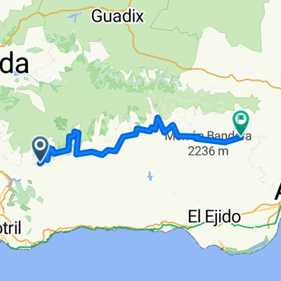
Constant ascent on good path and track, at the end is the recreational area of Puente Palo; for the daring, if they continue ahead on the flat path, they could reach the houses of Tello after crossing the Lanjarón River.
- -:--
- Duration
- 10.8 km
- Distance
- 932 m
- Ascent
- 106 m
- Descent
- ---
- Avg. speed
- ---
- Max. altitude

Route highlights
Points of interest along the route
Point of interest after 0 km
Ermita del Padre Eterno
Point of interest after 10.7 km
Puentepalo
Continue with Bikemap
Use, edit, or download this cycling route
You would like to ride Ermita del Padre Eterno - Puentepalo or customize it for your own trip? Here is what you can do with this Bikemap route:
Free features
- Save this route as favorite or in collections
- Copy & plan your own version of this route
- Sync your route with Garmin or Wahoo
Premium features
Free trial for 3 days, or one-time payment. More about Bikemap Premium.
- Navigate this route on iOS & Android
- Export a GPX / KML file of this route
- Create your custom printout (try it for free)
- Download this route for offline navigation
Discover more Premium features.
Get Bikemap PremiumFrom our community
Other popular routes starting in Soportújar
 Ermita del Padre Eterno - Puentepalo
- Distance
- 10.8 km
- Ascent
- 932 m
- Descent
- 106 m
- Location
- Soportújar, Andalusia, Spain
 Transnevada (Stage 6 / 8)
- Distance
- 48.3 km
- Ascent
- 2,148 m
- Descent
- 2,055 m
- Location
- Soportújar, Andalusia, Spain
 Granada to Cortijo de la Angrailla, Soportújar
- Distance
- 449.6 km
- Ascent
- 19,795 m
- Descent
- 19,679 m
- Location
- Soportújar, Andalusia, Spain
 Por la alpujarra
- Distance
- 17.3 km
- Ascent
- 1,350 m
- Descent
- 61 m
- Location
- Soportújar, Andalusia, Spain
 Soportújar - Canjáyar
- Distance
- 94.5 km
- Ascent
- 989 m
- Descent
- 831 m
- Location
- Soportújar, Andalusia, Spain
 Soportujar Sendero
- Distance
- 1.4 km
- Ascent
- 189 m
- Descent
- 86 m
- Location
- Soportújar, Andalusia, Spain
 Transnevada
- Distance
- 458.7 km
- Ascent
- 5,458 m
- Descent
- 5,467 m
- Location
- Soportújar, Andalusia, Spain
 circuito a siera nevada
- Distance
- 198.5 km
- Ascent
- 7,692 m
- Descent
- 5,090 m
- Location
- Soportújar, Andalusia, Spain
Open it in the app