
Feierabendrunde (Sachsen/Freiberg)
A cycling route starting in Brand-Erbisdorf, Saxony, Germany.
Overview
About this route
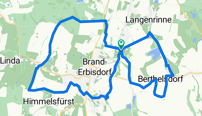
A lovely evening ride near Freiberg/Saxony. The route takes you through Berthelsdorf, Zug (the route intersects at Konstantinschacht), Freiberg Stadtwald, St. Michaelis, and Brand Erbisdorf.
- -:--
- Duration
- 21.1 km
- Distance
- 270 m
- Ascent
- 271 m
- Descent
- ---
- Avg. speed
- 510 m
- Max. altitude
Route photos
\"")
\"")
Route quality
Waytypes & surfaces along the route
Waytypes
Quiet road
9.9 km
(47 %)
Track
4.2 km
(20 %)
Surfaces
Paved
16.5 km
(78 %)
Unpaved
3.6 km
(17 %)
Asphalt
15.4 km
(73 %)
Ground
1.5 km
(7 %)
Continue with Bikemap
Use, edit, or download this cycling route
You would like to ride Feierabendrunde (Sachsen/Freiberg) or customize it for your own trip? Here is what you can do with this Bikemap route:
Free features
- Save this route as favorite or in collections
- Copy & plan your own version of this route
- Sync your route with Garmin or Wahoo
Premium features
Free trial for 3 days, or one-time payment. More about Bikemap Premium.
- Navigate this route on iOS & Android
- Export a GPX / KML file of this route
- Create your custom printout (try it for free)
- Download this route for offline navigation
Discover more Premium features.
Get Bikemap PremiumFrom our community
Other popular routes starting in Brand-Erbisdorf
 Schwartenbergrunde
- Distance
- 74.1 km
- Ascent
- 877 m
- Descent
- 812 m
- Location
- Brand-Erbisdorf, Saxony, Germany
 BED - FG
- Distance
- 9.2 km
- Ascent
- 50 m
- Descent
- 101 m
- Location
- Brand-Erbisdorf, Saxony, Germany
 Feierabendrunde (Sachsen/Freiberg)
- Distance
- 21.1 km
- Ascent
- 270 m
- Descent
- 271 m
- Location
- Brand-Erbisdorf, Saxony, Germany
 Einstiegsrunde 2020 Brand-Erbisdorf/Langenau
- Distance
- 18.6 km
- Ascent
- 157 m
- Descent
- 164 m
- Location
- Brand-Erbisdorf, Saxony, Germany
 3 km W pochwerkteich 40hm
- Distance
- 3.3 km
- Ascent
- 56 m
- Descent
- 53 m
- Location
- Brand-Erbisdorf, Saxony, Germany
 Stadtgutweg 3C, Brand-Erbisdorf nach Drei-Brüder-Höhe 1, Marienberg
- Distance
- 175.6 km
- Ascent
- 2,492 m
- Descent
- 2,183 m
- Location
- Brand-Erbisdorf, Saxony, Germany
 Brand-Erbisdorf - Talsperre Mater
- Distance
- 28.3 km
- Ascent
- 313 m
- Descent
- 435 m
- Location
- Brand-Erbisdorf, Saxony, Germany
 Runde um Brand-Erbisdorf
- Distance
- 29.6 km
- Ascent
- 318 m
- Descent
- 314 m
- Location
- Brand-Erbisdorf, Saxony, Germany
Open it in the app