

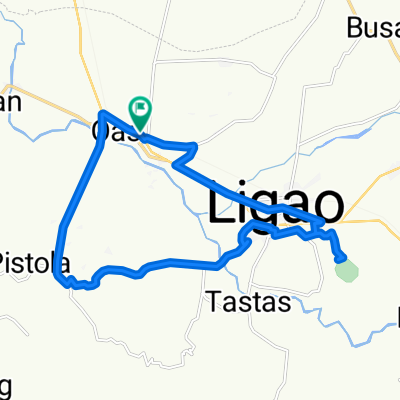
Tobgon River Loop avoiding National Hi-ways and Dense Roads
A cycling route starting in Iraya, Bicol Region, Philippines.
Overview
About this route
From Binatagan to Greenfield Road to Irrigation Road parallel to Tobgon River upstrem. Turned right to avoid Sabido Road and looped back via Sabloyon Road. Then made a right turn again at Batang to again avoid the national hi-way going back to Ligao Centro. And finally back to starting point.
- -:--
- Duration
- 15.7 km
- Distance
- 56 m
- Ascent
- 55 m
- Descent
- ---
- Avg. speed
- 98 m
- Max. altitude

Continue with Bikemap
Use, edit, or download this cycling route
You would like to ride Tobgon River Loop avoiding National Hi-ways and Dense Roads or customize it for your own trip? Here is what you can do with this Bikemap route:
Free features
- Save this route as favorite or in collections
- Copy & plan your own version of this route
- Sync your route with Garmin or Wahoo
Premium features
Free trial for 3 days, or one-time payment. More about Bikemap Premium.
- Navigate this route on iOS & Android
- Export a GPX / KML file of this route
- Create your custom printout (try it for free)
- Download this route for offline navigation
Discover more Premium features.
Get Bikemap PremiumFrom our community
Other popular routes starting in Iraya
 Municipal Road, Oas to Municipal Road, Oas
- Distance
- 42.9 km
- Ascent
- 21 m
- Descent
- 6 m
- Location
- Iraya, Bicol Region, Philippines
 Municipal Road, Oas to Municipal Road, Oas
- Distance
- 53.4 km
- Ascent
- 53 m
- Descent
- 46 m
- Location
- Iraya, Bicol Region, Philippines
 Maporong, Oas to Maporong, Oas
- Distance
- 12.3 km
- Ascent
- 391 m
- Descent
- 391 m
- Location
- Iraya, Bicol Region, Philippines
 Oas-Ponso Loop Clockwise
- Distance
- 20.3 km
- Ascent
- 43 m
- Descent
- 41 m
- Location
- Iraya, Bicol Region, Philippines
 Tobgon River Loop avoiding National Hi-ways and Dense Roads
- Distance
- 15.7 km
- Ascent
- 56 m
- Descent
- 55 m
- Location
- Iraya, Bicol Region, Philippines
 Municipal Road, Oas to Municipal Road, Oas
- Distance
- 39 km
- Ascent
- 254 m
- Descent
- 255 m
- Location
- Iraya, Bicol Region, Philippines
 Restful route
- Distance
- 22.8 km
- Ascent
- 126 m
- Descent
- 180 m
- Location
- Iraya, Bicol Region, Philippines
 Rumualdo Street, Oas to Amtic
- Distance
- 19.4 km
- Ascent
- 482 m
- Descent
- 55 m
- Location
- Iraya, Bicol Region, Philippines
Open it in the app