

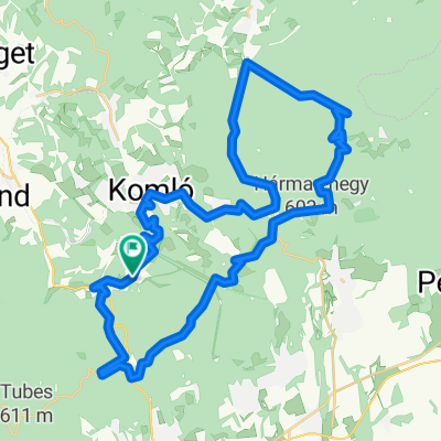
Mecsek
A cycling route starting in Komló, Baranya, Hungary.
Overview
About this route
- -:--
- Duration
- 152.2 km
- Distance
- 1,708 m
- Ascent
- 1,706 m
- Descent
- ---
- Avg. speed
- ---
- Max. altitude
Continue with Bikemap
Use, edit, or download this cycling route
You would like to ride Mecsek or customize it for your own trip? Here is what you can do with this Bikemap route:
Free features
- Save this route as favorite or in collections
- Copy & plan your own version of this route
- Split it into stages to create a multi-day tour
- Sync your route with Garmin or Wahoo
Premium features
Free trial for 3 days, or one-time payment. More about Bikemap Premium.
- Navigate this route on iOS & Android
- Export a GPX / KML file of this route
- Create your custom printout (try it for free)
- Download this route for offline navigation
Discover more Premium features.
Get Bikemap PremiumFrom our community
Other popular routes starting in Komló
 Cigányhegy
- Distance
- 15.3 km
- Ascent
- 419 m
- Descent
- 124 m
- Location
- Komló, Baranya, Hungary
 Komló-Magyarszék-Abaliget-Orfű
- Distance
- 41.8 km
- Ascent
- 308 m
- Descent
- 301 m
- Location
- Komló, Baranya, Hungary
 Kerékpárral Komló körül
- Distance
- 39.2 km
- Ascent
- 657 m
- Descent
- 733 m
- Location
- Komló, Baranya, Hungary
 Völgyi túra Komló és környékén
- Distance
- 21.7 km
- Ascent
- 226 m
- Descent
- 225 m
- Location
- Komló, Baranya, Hungary
 Mecsek Erdészeti út kör
- Distance
- 48.4 km
- Ascent
- 658 m
- Descent
- 658 m
- Location
- Komló, Baranya, Hungary
 Petőfi utca 11, Komló to Petőfi utca 11, Komló
- Distance
- 26.6 km
- Ascent
- 42 m
- Descent
- 95 m
- Location
- Komló, Baranya, Hungary
 DÖKE Jó szerencsét teljesítménytúra
- Distance
- 58.4 km
- Ascent
- 441 m
- Descent
- 441 m
- Location
- Komló, Baranya, Hungary
 Mecsek
- Distance
- 152.2 km
- Ascent
- 1,708 m
- Descent
- 1,706 m
- Location
- Komló, Baranya, Hungary
Open it in the app