
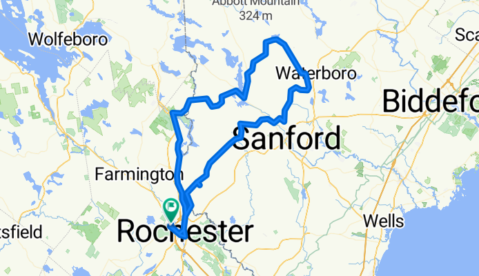
Lebanon-Springvale-Waterboro-Shapleigh Milton Mills Loop
A cycling route starting in Rochester, New Hampshire, United States.
Overview
About this route
Slightly longer and challenging route. Good scenery, low traffic and a white-knuckle descent into Milton Mills!
- -:--
- Duration
- 106.8 km
- Distance
- 635 m
- Ascent
- 636 m
- Descent
- ---
- Avg. speed
- ---
- Max. altitude
Route quality
Waytypes & surfaces along the route
Waytypes
Quiet road
58.8 km
(55 %)
Road
15 km
(14 %)
Surfaces
Paved
88.7 km
(83 %)
Asphalt
88.7 km
(83 %)
Undefined
18.2 km
(17 %)
Continue with Bikemap
Use, edit, or download this cycling route
You would like to ride Lebanon-Springvale-Waterboro-Shapleigh Milton Mills Loop or customize it for your own trip? Here is what you can do with this Bikemap route:
Free features
- Save this route as favorite or in collections
- Copy & plan your own version of this route
- Split it into stages to create a multi-day tour
- Sync your route with Garmin or Wahoo
Premium features
Free trial for 3 days, or one-time payment. More about Bikemap Premium.
- Navigate this route on iOS & Android
- Export a GPX / KML file of this route
- Create your custom printout (try it for free)
- Download this route for offline navigation
Discover more Premium features.
Get Bikemap PremiumFrom our community
Other popular routes starting in Rochester
 Blueberry Hill - Lovell Lake
- Distance
- 78.7 km
- Ascent
- 566 m
- Descent
- 563 m
- Location
- Rochester, New Hampshire, United States
 Early Riser - Shapleigh Route v1
- Distance
- 32.6 km
- Ascent
- 262 m
- Descent
- 261 m
- Location
- Rochester, New Hampshire, United States
 Alton Circle TT route
- Distance
- 42.6 km
- Ascent
- 188 m
- Descent
- 188 m
- Location
- Rochester, New Hampshire, United States
 Ridges 'round Rochester - ver II
- Distance
- 77.7 km
- Ascent
- 839 m
- Descent
- 836 m
- Location
- Rochester, New Hampshire, United States
 Parker Mountain Loop
- Distance
- 69.6 km
- Ascent
- 636 m
- Descent
- 636 m
- Location
- Rochester, New Hampshire, United States
 Early Riser: Hornetown Hill Out-and-back
- Distance
- 41.2 km
- Ascent
- 313 m
- Descent
- 314 m
- Location
- Rochester, New Hampshire, United States
 Early Riser - Evergreen Valley
- Distance
- 31.9 km
- Ascent
- 294 m
- Descent
- 295 m
- Location
- Rochester, New Hampshire, United States
 Nubble Light Loop
- Distance
- 106.9 km
- Ascent
- 325 m
- Descent
- 327 m
- Location
- Rochester, New Hampshire, United States
Open it in the app