

Mount Shasta Cycling
A cycling route starting in Mount Shasta, California, United States.
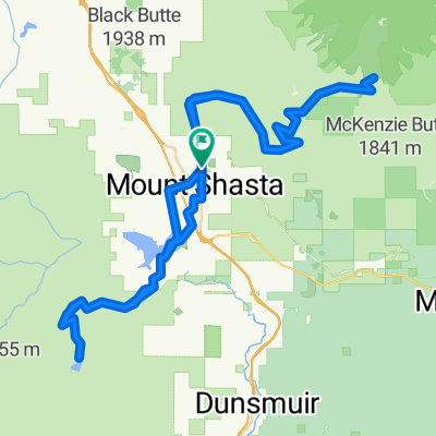
Overview
About this route
- -:--
- Duration
- 10.7 km
- Distance
- 253 m
- Ascent
- 238 m
- Descent
- ---
- Avg. speed
- 1,333 m
- Max. altitude

Continue with Bikemap
Use, edit, or download this cycling route
You would like to ride Mount Shasta Cycling or customize it for your own trip? Here is what you can do with this Bikemap route:
Free features
- Save this route as favorite or in collections
- Copy & plan your own version of this route
- Sync your route with Garmin or Wahoo
Premium features
Free trial for 3 days, or one-time payment. More about Bikemap Premium.
- Navigate this route on iOS & Android
- Export a GPX / KML file of this route
- Create your custom printout (try it for free)
- Download this route for offline navigation
Discover more Premium features.
Get Bikemap PremiumFrom our community
Other popular routes starting in Mount Shasta
 Mount Shasta Cycling
- Distance
- 9.7 km
- Ascent
- 176 m
- Descent
- 170 m
- Location
- Mount Shasta, California, United States
 21. Mt. Shasta - Fall River Mills
- Distance
- 102.1 km
- Ascent
- 989 m
- Descent
- 1,073 m
- Location
- Mount Shasta, California, United States
 Northern California - Southern Oregon Loop
- Distance
- 1,016.4 km
- Ascent
- 5,889 m
- Descent
- 5,885 m
- Location
- Mount Shasta, California, United States
 Mount Shasta Cycling
- Distance
- 10.7 km
- Ascent
- 253 m
- Descent
- 238 m
- Location
- Mount Shasta, California, United States
 Mt. Shasta 2 climbs
- Distance
- 80.4 km
- Ascent
- 2,031 m
- Descent
- 2,031 m
- Location
- Mount Shasta, California, United States
 Mount Shasta Cycling
- Distance
- 16 km
- Ascent
- 538 m
- Descent
- 536 m
- Location
- Mount Shasta, California, United States
 Mt. Shasta Summit Century
- Distance
- 154.5 km
- Ascent
- 2,863 m
- Descent
- 2,862 m
- Location
- Mount Shasta, California, United States
 Siskiyou to Gumboot
- Distance
- 42.6 km
- Ascent
- 902 m
- Descent
- 904 m
- Location
- Mount Shasta, California, United States
Open it in the app