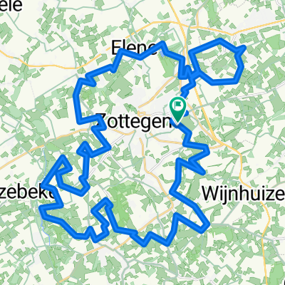
Watermolenroute - 42.3
A cycling route starting in Zottegem, Flemish Region, Belgium.
Overview
About this route
- -:--
- Duration
- 42.3 km
- Distance
- 477 m
- Ascent
- 477 m
- Descent
- ---
- Avg. speed
- 97 m
- Avg. speed
Route quality
Waytypes & surfaces along the route
Waytypes
Quiet road
38.9 km
(92 %)
Busy road
1.5 km
(3 %)
Surfaces
Paved
35.1 km
(83 %)
Unpaved
0.2 km
(<1 %)
Asphalt
26.6 km
(63 %)
Concrete
8.3 km
(20 %)
Route highlights
Points of interest along the route
Point of interest after 1.3 km
zwalmmolen
Point of interest after 2.5 km
pedes molen
Point of interest after 3.3 km
kassei
Point of interest after 3.7 km
kassei
Point of interest after 4.3 km
bareelke
Point of interest after 4.6 km
kassei
Point of interest after 6.1 km
bostmolen
Point of interest after 7.5 km
boembekemolen
Point of interest after 11.6 km
hol van pluto
Point of interest after 17.3 km
moldergemmolen
Point of interest after 17.5 km
molenberg kassei
Point of interest after 18.9 km
de vliegende hollander
Point of interest after 24.6 km
ijzerkotmolen
Point of interest after 25.2 km
spaans hof
Point of interest after 27.1 km
biestmolen
Continue with Bikemap
Use, edit, or download this cycling route
You would like to ride Watermolenroute - 42.3 or customize it for your own trip? Here is what you can do with this Bikemap route:
Free features
- Save this route as favorite or in collections
- Copy & plan your own version of this route
- Sync your route with Garmin or Wahoo
Premium features
Free trial for 3 days, or one-time payment. More about Bikemap Premium.
- Navigate this route on iOS & Android
- Export a GPX / KML file of this route
- Create your custom printout (try it for free)
- Download this route for offline navigation
Discover more Premium features.
Get Bikemap PremiumFrom our community
Other popular routes starting in Zottegem
- Watermolenroute - 42.3
- Distance
- 42.3 km
- Ascent
- 477 m
- Descent
- 477 m
- Location
- Zottegem, Flemish Region, Belgium
- dag 1 Fatima
- Distance
- 195.6 km
- Ascent
- 1,113 m
- Descent
- 1,152 m
- Location
- Zottegem, Flemish Region, Belgium
- munkzwalm1 - 72.5
- Distance
- 72.5 km
- Ascent
- 962 m
- Descent
- 962 m
- Location
- Zottegem, Flemish Region, Belgium
- rit zottegem 2.1
- Distance
- 53.4 km
- Ascent
- 311 m
- Descent
- 311 m
- Location
- Zottegem, Flemish Region, Belgium
- NAMIDDAGRITJE
- Distance
- 18.1 km
- Ascent
- 153 m
- Descent
- 166 m
- Location
- Zottegem, Flemish Region, Belgium
- Zottegem - Egmont VTT
- Distance
- 43.4 km
- Ascent
- 364 m
- Descent
- 363 m
- Location
- Zottegem, Flemish Region, Belgium
- toerke zondag
- Distance
- 39.1 km
- Ascent
- 337 m
- Descent
- 324 m
- Location
- Zottegem, Flemish Region, Belgium
- Mullem
- Distance
- 61.7 km
- Ascent
- 152 m
- Descent
- 154 m
- Location
- Zottegem, Flemish Region, Belgium
Open it in the app