

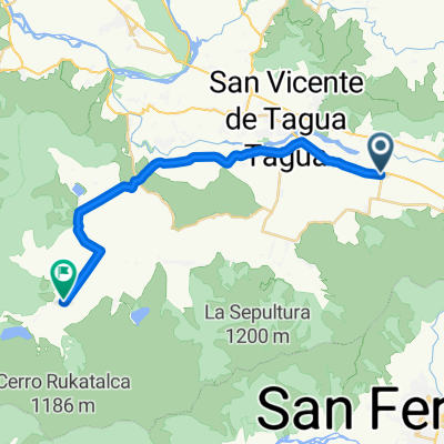
De Callejón Tiralarga 54, San Vicente de Taguatagua a Francia 1119, San Vicente de Taguatagua
A cycling route starting in San Vicente de Tagua Tagua, O'Higgins Region, Chile.
Overview
About this route
- 1 h 22 min
- Duration
- 20.3 km
- Distance
- 106 m
- Ascent
- 109 m
- Descent
- 14.9 km/h
- Avg. speed
- ---
- Max. altitude

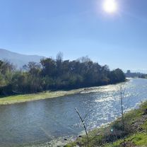
Route photos


Route quality
Waytypes & surfaces along the route
Waytypes
Road
5.5 km
(27 %)
Quiet road
4.1 km
(20 %)
Surfaces
Paved
16.3 km
(80 %)
Unpaved
0.8 km
(4 %)
Paved (undefined)
12.4 km
(61 %)
Asphalt
3.5 km
(17 %)
Continue with Bikemap
Use, edit, or download this cycling route
You would like to ride De Callejón Tiralarga 54, San Vicente de Taguatagua a Francia 1119, San Vicente de Taguatagua or customize it for your own trip? Here is what you can do with this Bikemap route:
Free features
- Save this route as favorite or in collections
- Copy & plan your own version of this route
- Sync your route with Garmin or Wahoo
Premium features
Free trial for 3 days, or one-time payment. More about Bikemap Premium.
- Navigate this route on iOS & Android
- Export a GPX / KML file of this route
- Create your custom printout (try it for free)
- Download this route for offline navigation
Discover more Premium features.
Get Bikemap PremiumFrom our community
Other popular routes starting in San Vicente de Tagua Tagua
 Paseito por Sta.Ines-Antivero-El Tambo
- Distance
- 16.5 km
- Ascent
- 71 m
- Descent
- 72 m
- Location
- San Vicente de Tagua Tagua, O'Higgins Region, Chile
 De Francia 1119, San Vicente de Taguatagua a Francia 1119, San Vicente de Taguatagua
- Distance
- 19.5 km
- Ascent
- 75 m
- Descent
- 38 m
- Location
- San Vicente de Tagua Tagua, O'Higgins Region, Chile
 De Presidente Carlos Ibañez del Campo 343, San Vicente de Taguatagua a Presidente Carlos Ibañez del Campo 343, San Vicente de Taguatagua
- Distance
- 45.2 km
- Ascent
- 260 m
- Descent
- 250 m
- Location
- San Vicente de Tagua Tagua, O'Higgins Region, Chile
 probando app
- Distance
- 24.7 km
- Ascent
- 901 m
- Descent
- 899 m
- Location
- San Vicente de Tagua Tagua, O'Higgins Region, Chile
 De Callejón Tiralarga 54, San Vicente de Taguatagua a Francia 1119, San Vicente de Taguatagua
- Distance
- 20.3 km
- Ascent
- 106 m
- Descent
- 109 m
- Location
- San Vicente de Tagua Tagua, O'Higgins Region, Chile
 millahue
- Distance
- 25 km
- Ascent
- 95 m
- Descent
- 112 m
- Location
- San Vicente de Tagua Tagua, O'Higgins Region, Chile
 Rally San Vicente XCM 2013
- Distance
- 53.8 km
- Ascent
- 866 m
- Descent
- 865 m
- Location
- San Vicente de Tagua Tagua, O'Higgins Region, Chile
 De Barros Arana 191, San Vicente de Taguatagua a Presidente Carlos Ibañez del Campo 343, San Vicente de Taguatagua
- Distance
- 14.5 km
- Ascent
- 90 m
- Descent
- 83 m
- Location
- San Vicente de Tagua Tagua, O'Higgins Region, Chile
Open it in the app