
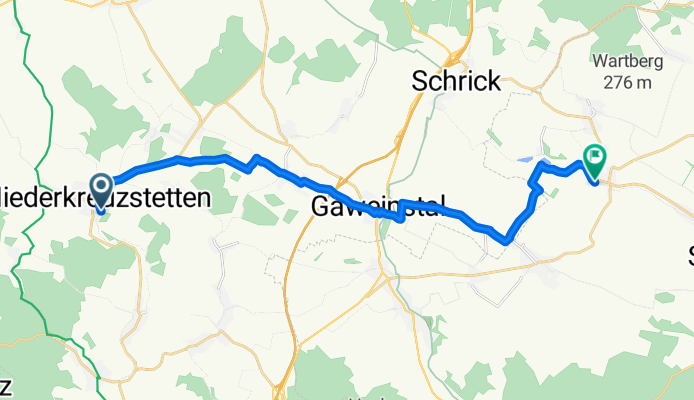
EFr-20081006 - Niederkreuzstetten > Niedersulz
A cycling route starting in Hochleithen, Lower Austria, Austria.
Overview
About this route
Ausflug mit Bahnunterstützung.
Der Radweg Nr. 7 ist zw. Gaweinstal und Martinsdorf schlecht beschildert. Daher "Ausflug" auf die Straße.
- -:--
- Duration
- 19.2 km
- Distance
- 159 m
- Ascent
- 202 m
- Descent
- ---
- Avg. speed
- 289 m
- Avg. speed
Route quality
Waytypes & surfaces along the route
Waytypes
Quiet road
6.5 km
(34 %)
Track
5.5 km
(28 %)
Surfaces
Paved
4.8 km
(25 %)
Unpaved
6.2 km
(32 %)
Gravel
5 km
(26 %)
Asphalt
2.7 km
(14 %)
Continue with Bikemap
Use, edit, or download this cycling route
You would like to ride EFr-20081006 - Niederkreuzstetten > Niedersulz or customize it for your own trip? Here is what you can do with this Bikemap route:
Free features
- Save this route as favorite or in collections
- Copy & plan your own version of this route
- Sync your route with Garmin or Wahoo
Premium features
Free trial for 3 days, or one-time payment. More about Bikemap Premium.
- Navigate this route on iOS & Android
- Export a GPX / KML file of this route
- Create your custom printout (try it for free)
- Download this route for offline navigation
Discover more Premium features.
Get Bikemap PremiumFrom our community
Other popular routes starting in Hochleithen
 Restful route in Spannberg
- Distance
- 20 km
- Ascent
- 289 m
- Descent
- 405 m
- Location
- Hochleithen, Lower Austria, Austria
 Niederkreuzstetten erweiterte Kreuttalrunden
- Distance
- 59.5 km
- Ascent
- 391 m
- Descent
- 389 m
- Location
- Hochleithen, Lower Austria, Austria
 Rußbachweg, Kreuttalradweg
- Distance
- 52.5 km
- Ascent
- 461 m
- Descent
- 464 m
- Location
- Hochleithen, Lower Austria, Austria
 Niederkreuzstetten-Wolkersdorf-Kagran-Alten Donau, Wien
- Distance
- 41.7 km
- Ascent
- 137 m
- Descent
- 216 m
- Location
- Hochleithen, Lower Austria, Austria
 Kreutal
- Distance
- 48.8 km
- Ascent
- 222 m
- Descent
- 222 m
- Location
- Hochleithen, Lower Austria, Austria
 Wolfpassing-Kreuttal-Karnabrunn-Großmugl-Obergänserndorf-retour
- Distance
- 78.3 km
- Ascent
- 483 m
- Descent
- 483 m
- Location
- Hochleithen, Lower Austria, Austria
 EFr-20081006 - Niederkreuzstetten > Niedersulz
- Distance
- 19.2 km
- Ascent
- 159 m
- Descent
- 202 m
- Location
- Hochleithen, Lower Austria, Austria
 Niederkreuzstetten_Groruba_zufuss
- Distance
- 6.3 km
- Ascent
- 135 m
- Descent
- 101 m
- Location
- Hochleithen, Lower Austria, Austria
Open it in the app