Erding - Airport - Erding
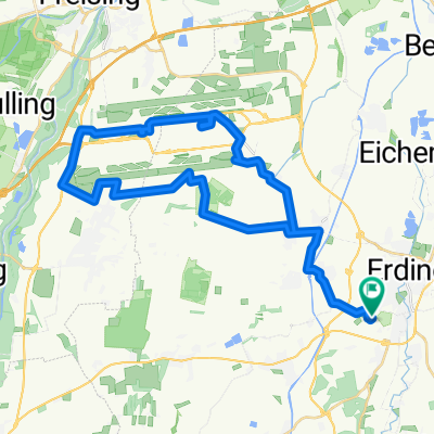
A cycling route starting in Stammham, Bavaria, Germany.
Overview
About this route
Von der Therme Erding um die Südbahn des Airport München und zurück
- -:--
- Duration
- 41.1 km
- Distance
- 89 m
- Ascent
- 85 m
- Descent
- ---
- Avg. speed
- 486 m
- Max. altitude
Route quality
Waytypes & surfaces along the route
Waytypes
Quiet road
14.8 km
(36 %)
Path
9 km
(22 %)
Surfaces
Paved
30.4 km
(74 %)
Unpaved
4.5 km
(11 %)
Asphalt
28.8 km
(70 %)
Gravel
4.5 km
(11 %)
Continue with Bikemap
Use, edit, or download this cycling route
You would like to ride Erding - Airport - Erding or customize it for your own trip? Here is what you can do with this Bikemap route:
Free features
- Save this route as favorite or in collections
- Copy & plan your own version of this route
- Sync your route with Garmin or Wahoo
Premium features
Free trial for 3 days, or one-time payment. More about Bikemap Premium.
- Navigate this route on iOS & Android
- Export a GPX / KML file of this route
- Create your custom printout (try it for free)
- Download this route for offline navigation
Discover more Premium features.
Get Bikemap PremiumFrom our community
Other popular routes starting in Stammham
Freising und Flughafen- Distance
- 46.6 km
- Ascent
- 101 m
- Descent
- 100 m
- Location
- Stammham, Bavaria, Germany
Gerade Fahrt in Erding- Distance
- 4.3 km
- Ascent
- 4 m
- Descent
- 4 m
- Location
- Stammham, Bavaria, Germany
Andi1- Distance
- 16.7 km
- Ascent
- 34 m
- Descent
- 33 m
- Location
- Stammham, Bavaria, Germany
Erdings Westen (kurz)- Distance
- 27.7 km
- Ascent
- 41 m
- Descent
- 43 m
- Location
- Stammham, Bavaria, Germany
Aufkirchen - Regensburg - Luis- Distance
- 115.7 km
- Ascent
- 239 m
- Descent
- 374 m
- Location
- Stammham, Bavaria, Germany
Challenge #2- Distance
- 50.9 km
- Ascent
- 148 m
- Descent
- 147 m
- Location
- Stammham, Bavaria, Germany
Erding to Wildparkstraße 32, Poing- Distance
- 20.1 km
- Ascent
- 105 m
- Descent
- 52 m
- Location
- Stammham, Bavaria, Germany
Lange Radrunde durch Erding- Distance
- 36.5 km
- Ascent
- 80 m
- Descent
- 77 m
- Location
- Stammham, Bavaria, Germany
Open it in the app

