
Samoeng Loop
A cycling route starting in Chiang Mai, Chiang Mai Province, Thailand.
Overview
About this route
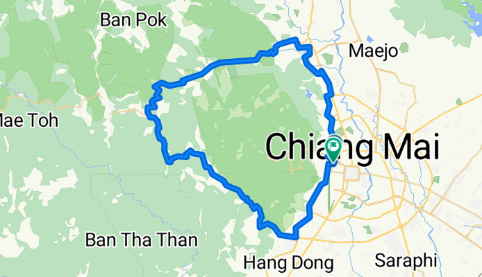
Classic Ride around the mountains of Chiang Mai:
From Chiang Mai take Canal Road South to Samoeng Intersection. Then enter the valley in Eastern direction eventually starting to climb. After km 35 and reaching an altitude of approx 800 m, several steep switchbacks will take you down to about 550 m above sea level. The next climb is 5 kms and 400 m climb.
After the next downhill of about 2 km, take a right turn direction Mae Rim and do the third and final climb.
You will be rewarded with a nice and extended downhill.
At km 69 turn right, and at km 71 - after crossing a bridge - again right. Then follow the road along the river until you reach highway 107. U-turn there and follow direction Chiang Mai then at km 78 turn right at the traffic lights to follow Canal Road back to Chiang Mai.
- -:--
- Duration
- 87.7 km
- Distance
- 1,132 m
- Ascent
- 1,130 m
- Descent
- ---
- Avg. speed
- ---
- Avg. speed
Continue with Bikemap
Use, edit, or download this cycling route
You would like to ride Samoeng Loop or customize it for your own trip? Here is what you can do with this Bikemap route:
Free features
- Save this route as favorite or in collections
- Copy & plan your own version of this route
- Split it into stages to create a multi-day tour
- Sync your route with Garmin or Wahoo
Premium features
Free trial for 3 days, or one-time payment. More about Bikemap Premium.
- Navigate this route on iOS & Android
- Export a GPX / KML file of this route
- Create your custom printout (try it for free)
- Download this route for offline navigation
Discover more Premium features.
Get Bikemap PremiumFrom our community
Other popular routes starting in Chiang Mai
 Chiangmai U to Doi Su Thep view point
- Distance
- 18.1 km
- Ascent
- 404 m
- Descent
- 403 m
- Location
- Chiang Mai, Chiang Mai Province, Thailand
 CPB small circle
- Distance
- 13.7 km
- Ascent
- 73 m
- Descent
- 71 m
- Location
- Chiang Mai, Chiang Mai Province, Thailand
 MTCM - ITT Huay Tung Thao Lake
- Distance
- 8.3 km
- Ascent
- 72 m
- Descent
- 78 m
- Location
- Chiang Mai, Chiang Mai Province, Thailand
 Reverse Samoeng Loop back via Bhubbing Palace
- Distance
- 116.8 km
- Ascent
- 2,847 m
- Descent
- 2,847 m
- Location
- Chiang Mai, Chiang Mai Province, Thailand
 straight to samoeng
- Distance
- 41.2 km
- Ascent
- 1,028 m
- Descent
- 849 m
- Location
- Chiang Mai, Chiang Mai Province, Thailand
 Phuping Palace
- Distance
- 52.2 km
- Ascent
- 1,083 m
- Descent
- 1,098 m
- Location
- Chiang Mai, Chiang Mai Province, Thailand
 Chiang Mai - Rim Ping
- Distance
- 65 km
- Ascent
- 30 m
- Descent
- 29 m
- Location
- Chiang Mai, Chiang Mai Province, Thailand
 Cycle in Thai 03 : Chiang Rai, Myanmar
- Distance
- 263.6 km
- Ascent
- 781 m
- Descent
- 703 m
- Location
- Chiang Mai, Chiang Mai Province, Thailand
Open it in the app