
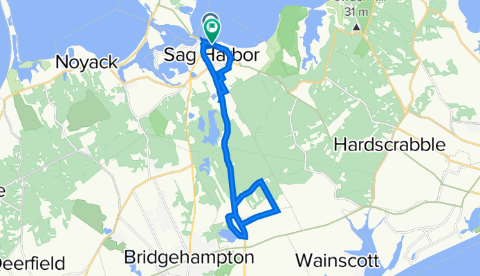
Marine Park Dr, Sag Harbor to 34 Bay St, Sag Harbor
A cycling route starting in Sag Harbor, New York, United States.
Overview
About this route
- 1 h 9 min
- Duration
- 20.2 km
- Distance
- 0 m
- Ascent
- 3 m
- Descent
- 17.5 km/h
- Avg. speed
- ---
- Max. altitude
Route quality
Waytypes & surfaces along the route
Waytypes
Quiet road
6.3 km
(31 %)
Road
1.2 km
(6 %)
Surfaces
Paved
18 km
(89 %)
Asphalt
18 km
(89 %)
Undefined
2.2 km
(11 %)
Continue with Bikemap
Use, edit, or download this cycling route
You would like to ride Marine Park Dr, Sag Harbor to 34 Bay St, Sag Harbor or customize it for your own trip? Here is what you can do with this Bikemap route:
Free features
- Save this route as favorite or in collections
- Copy & plan your own version of this route
- Sync your route with Garmin or Wahoo
Premium features
Free trial for 3 days, or one-time payment. More about Bikemap Premium.
- Navigate this route on iOS & Android
- Export a GPX / KML file of this route
- Create your custom printout (try it for free)
- Download this route for offline navigation
Discover more Premium features.
Get Bikemap PremiumFrom our community
Other popular routes starting in Sag Harbor
 Marine Park Dr, Sag Harbor to 34 Bay St, Sag Harbor
- Distance
- 20.2 km
- Ascent
- 0 m
- Descent
- 3 m
- Location
- Sag Harbor, New York, United States
 160 S Ferry Rd, North Haven to S Ferry Rd, North Haven
- Distance
- 34.6 km
- Ascent
- 157 m
- Descent
- 158 m
- Location
- Sag Harbor, New York, United States
 31 W Water St, Sag Harbor to 31 W Water St, Sag Harbor
- Distance
- 22.6 km
- Ascent
- 101 m
- Descent
- 101 m
- Location
- Sag Harbor, New York, United States
 skipped airport
- Distance
- 8.9 km
- Ascent
- 33 m
- Descent
- 43 m
- Location
- Sag Harbor, New York, United States
 Recovered Route
- Distance
- 5.5 km
- Ascent
- 54 m
- Descent
- 29 m
- Location
- Sag Harbor, New York, United States
 Sunset Beach
- Distance
- 33.9 km
- Ascent
- 158 m
- Descent
- 158 m
- Location
- Sag Harbor, New York, United States
 56 Main St, Sag Harbor to 40 N Ferry Rd, Shelter Island
- Distance
- 9.6 km
- Ascent
- 59 m
- Descent
- 46 m
- Location
- Sag Harbor, New York, United States
 22 Long Island Ave, Sag Harbor to 38 Lake Dr, Southampton
- Distance
- 12.6 km
- Ascent
- 0 m
- Descent
- 3 m
- Location
- Sag Harbor, New York, United States
Open it in the app