

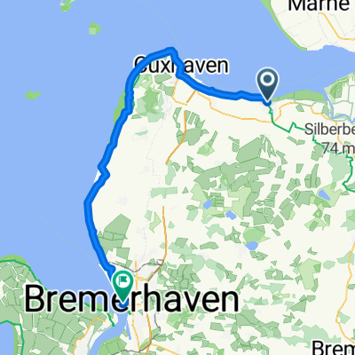
Rund um Otterndorf CLONED FROM ROUTE 824401
A cycling route starting in Otterndorf, Lower Saxony, Germany.
Overview
About this route
The cycling route 'Rund um Otterndorf' runs along the Hadelner Canal and the wild-romantic Oste with its modern weir. Old churches, modern radar towers, and the historic old town of Otterndorf invite visitors to admire and linger.
Route / Sights: Holiday resort 'Achtern Diek' with swimming lake, large adventure playground, play barn in Otterndorf - Kranichhaus, cultural and folklore museum in Otterndorf - St. Vitus Church in Belum - St. Mary's Church in Neuenkirchen - Windmill museum in Osterbruch - Eastern weir in Neuhaus - Natureum Niederelbe in Neuhaus.
- -:--
- Duration
- 49.7 km
- Distance
- 4 m
- Ascent
- 4 m
- Descent
- ---
- Avg. speed
- ---
- Max. altitude
Route quality
Waytypes & surfaces along the route
Waytypes
Quiet road
30.3 km
(61 %)
Track
9.4 km
(19 %)
Surfaces
Paved
41.7 km
(84 %)
Unpaved
0.5 km
(1 %)
Asphalt
39.2 km
(79 %)
Paved (undefined)
2.5 km
(5 %)
Continue with Bikemap
Use, edit, or download this cycling route
You would like to ride Rund um Otterndorf CLONED FROM ROUTE 824401 or customize it for your own trip? Here is what you can do with this Bikemap route:
Free features
- Save this route as favorite or in collections
- Copy & plan your own version of this route
- Sync your route with Garmin or Wahoo
Premium features
Free trial for 3 days, or one-time payment. More about Bikemap Premium.
- Navigate this route on iOS & Android
- Export a GPX / KML file of this route
- Create your custom printout (try it for free)
- Download this route for offline navigation
Discover more Premium features.
Get Bikemap PremiumFrom our community
Other popular routes starting in Otterndorf
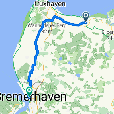 Otterndorf- Bremerhaven
- Distance
- 53.3 km
- Ascent
- 87 m
- Descent
- 86 m
- Location
- Otterndorf, Lower Saxony, Germany
 Seeluft...
- Distance
- 53.7 km
- Ascent
- 23 m
- Descent
- 22 m
- Location
- Otterndorf, Lower Saxony, Germany
 Imkes Irrweg
- Distance
- 10.9 km
- Ascent
- 4 m
- Descent
- 4 m
- Location
- Otterndorf, Lower Saxony, Germany
 Deichstraße 41, Otterndorf nach Bei der Alten Liebe 1, Cuxhaven
- Distance
- 13.5 km
- Ascent
- 6 m
- Descent
- 4 m
- Location
- Otterndorf, Lower Saxony, Germany
 Schleusenstraße nach Am Neuen Hafen
- Distance
- 70.1 km
- Ascent
- 32 m
- Descent
- 30 m
- Location
- Otterndorf, Lower Saxony, Germany
 Otterndorf-Sylt
- Distance
- 316.8 km
- Ascent
- 17 m
- Descent
- 14 m
- Location
- Otterndorf, Lower Saxony, Germany
 Rund um Otterndorf CLONED FROM ROUTE 824401
- Distance
- 49.7 km
- Ascent
- 4 m
- Descent
- 4 m
- Location
- Otterndorf, Lower Saxony, Germany
 Schultheiss-Gerhard-Schneider-Weg, Otterndorf nach Elberadweg 3, Cuxhaven
- Distance
- 16.1 km
- Ascent
- 13 m
- Descent
- 6 m
- Location
- Otterndorf, Lower Saxony, Germany
Open it in the app