Chemnitztalbahn Diethensdorf - Chemnitz
A cycling route starting in Wittgensdorf, Saxony, Germany.
Overview
About this route
- -:--
- Duration
- 36.9 km
- Distance
- 117 m
- Ascent
- 115 m
- Descent
- ---
- Avg. speed
- 299 m
- Avg. speed
Route quality
Waytypes & surfaces along the route
Waytypes
Cycleway
14.7 km
(40 %)
Path
13.4 km
(36 %)
Surfaces
Paved
36.1 km
(98 %)
Asphalt
33 km
(90 %)
Paving stones
2.3 km
(6 %)
Continue with Bikemap
Use, edit, or download this cycling route
You would like to ride Chemnitztalbahn Diethensdorf - Chemnitz or customize it for your own trip? Here is what you can do with this Bikemap route:
Free features
- Save this route as favorite or in collections
- Copy & plan your own version of this route
- Sync your route with Garmin or Wahoo
Premium features
Free trial for 3 days, or one-time payment. More about Bikemap Premium.
- Navigate this route on iOS & Android
- Export a GPX / KML file of this route
- Create your custom printout (try it for free)
- Download this route for offline navigation
Discover more Premium features.
Get Bikemap PremiumFrom our community
Other popular routes starting in Wittgensdorf
- gute Grundlagenrunde, nur leichte, kurze Steigungen
- Distance
- 45.7 km
- Ascent
- 331 m
- Descent
- 288 m
- Location
- Wittgensdorf, Saxony, Germany
- Taurastein-Sachsenburg(Hängebrücke)-Frankenberg(Schilfteich)
- Distance
- 48.5 km
- Ascent
- 301 m
- Descent
- 301 m
- Location
- Wittgensdorf, Saxony, Germany
- RK Rabenstein(Totenstein) - Mittelbach - Neukirchen - Klaffenbach
- Distance
- 43.5 km
- Ascent
- 312 m
- Descent
- 313 m
- Location
- Wittgensdorf, Saxony, Germany
- Crimmitschauer-Küchwald-Strecke (S01)
- Distance
- 6.6 km
- Ascent
- 97 m
- Descent
- 109 m
- Location
- Wittgensdorf, Saxony, Germany
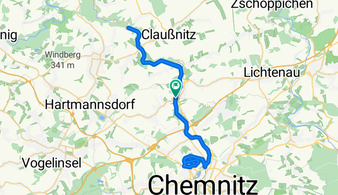
- Kleine Chemnitztalrunde
- Distance
- 52.6 km
- Ascent
- 314 m
- Descent
- 314 m
- Location
- Wittgensdorf, Saxony, Germany
- Chemnitztalbahn Diethensdorf - Chemnitz
- Distance
- 36.9 km
- Ascent
- 117 m
- Descent
- 115 m
- Location
- Wittgensdorf, Saxony, Germany
- Chemnitz Tour
- Distance
- 29.8 km
- Ascent
- 232 m
- Descent
- 239 m
- Location
- Wittgensdorf, Saxony, Germany
- MTB_Mittweida
- Distance
- 47 km
- Ascent
- 653 m
- Descent
- 652 m
- Location
- Wittgensdorf, Saxony, Germany