Von Rittsteig nach Klatovy und zurück
A cycling route starting in Nýrsko, Plzeň Region, Czechia.
Overview
About this route
- -:--
- Duration
- 72.5 km
- Distance
- 839 m
- Ascent
- 998 m
- Descent
- ---
- Avg. speed
- 705 m
- Max. altitude
Route quality
Waytypes & surfaces along the route
Waytypes
Quiet road
21 km
(29 %)
Track
15.9 km
(22 %)
Surfaces
Paved
10.9 km
(15 %)
Unpaved
14.5 km
(20 %)
Asphalt
10.1 km
(14 %)
Unpaved (undefined)
8.7 km
(12 %)
Continue with Bikemap
Use, edit, or download this cycling route
You would like to ride Von Rittsteig nach Klatovy und zurück or customize it for your own trip? Here is what you can do with this Bikemap route:
Free features
- Save this route as favorite or in collections
- Copy & plan your own version of this route
- Sync your route with Garmin or Wahoo
Premium features
Free trial for 3 days, or one-time payment. More about Bikemap Premium.
- Navigate this route on iOS & Android
- Export a GPX / KML file of this route
- Create your custom printout (try it for free)
- Download this route for offline navigation
Discover more Premium features.
Get Bikemap PremiumFrom our community
Other popular routes starting in Nýrsko
Nýrsko-Zelená Lhota-Hamry-Špičák-Černé jezero-Bílá Strž-Stateček-Nýrsko- Distance
- 48.5 km
- Ascent
- 760 m
- Descent
- 760 m
- Location
- Nýrsko, Plzeň Region, Czechia
Zelezna Lhota - Pancir - Cerne Jezero - Nyrsko- Distance
- 45 km
- Ascent
- 1,022 m
- Descent
- 1,035 m
- Location
- Nýrsko, Plzeň Region, Czechia
Hamry-Prenet-Nad Sjezdovkou-Na mustku-Pancir-Hojsova Straz- Distance
- 31.2 km
- Ascent
- 897 m
- Descent
- 897 m
- Location
- Nýrsko, Plzeň Region, Czechia
Vor Lomnice - Karlsbad 311 km- Distance
- 358.6 km
- Ascent
- 5,805 m
- Descent
- 6,089 m
- Location
- Nýrsko, Plzeň Region, Czechia
Hojsova Stráž - jezero Laka - Pancíř- Distance
- 67.7 km
- Ascent
- 1,367 m
- Descent
- 1,219 m
- Location
- Nýrsko, Plzeň Region, Czechia
Von Rittsteig nach Klatovy und zurück- Distance
- 72.5 km
- Ascent
- 839 m
- Descent
- 998 m
- Location
- Nýrsko, Plzeň Region, Czechia
Na Chodsko za Kozinou- Distance
- 91.8 km
- Ascent
- 872 m
- Descent
- 863 m
- Location
- Nýrsko, Plzeň Region, Czechia
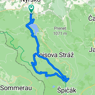
Stará Lhota - Černé Jezero- Distance
- 37.9 km
- Ascent
- 799 m
- Descent
- 804 m
- Location
- Nýrsko, Plzeň Region, Czechia
Open it in the app

