

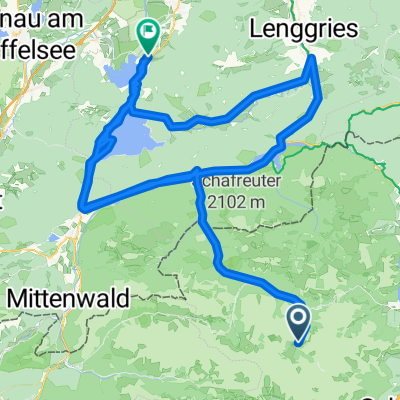
Hinterhorn / Walder Alm
A cycling route starting in Gnadenwald, Tyrol, Austria.
Overview
About this route
- -:--
- Duration
- 28.6 km
- Distance
- 915 m
- Ascent
- 1,081 m
- Descent
- ---
- Avg. speed
- 1,508 m
- Max. altitude
Route quality
Waytypes & surfaces along the route
Waytypes
Track
12.6 km
(44 %)
Quiet road
9.1 km
(32 %)
Surfaces
Paved
9.4 km
(33 %)
Unpaved
12.9 km
(45 %)
Gravel
10.3 km
(36 %)
Asphalt
9.4 km
(33 %)
Continue with Bikemap
Use, edit, or download this cycling route
You would like to ride Hinterhorn / Walder Alm or customize it for your own trip? Here is what you can do with this Bikemap route:
Free features
- Save this route as favorite or in collections
- Copy & plan your own version of this route
- Sync your route with Garmin or Wahoo
Premium features
Free trial for 3 days, or one-time payment. More about Bikemap Premium.
- Navigate this route on iOS & Android
- Export a GPX / KML file of this route
- Create your custom printout (try it for free)
- Download this route for offline navigation
Discover more Premium features.
Get Bikemap PremiumFrom our community
Other popular routes starting in Gnadenwald
 Gnadenwald Innsbruck und retour
- Distance
- 36.5 km
- Ascent
- 495 m
- Descent
- 495 m
- Location
- Gnadenwald, Tyrol, Austria
 rund wachensee and wally
- Distance
- 136.7 km
- Ascent
- 638 m
- Descent
- 1,216 m
- Location
- Gnadenwald, Tyrol, Austria
 Gnadenwald Rumer Alm
- Distance
- 25.4 km
- Ascent
- 614 m
- Descent
- 432 m
- Location
- Gnadenwald, Tyrol, Austria
 Main - Alpen 9. Teil: Eng-Alm - Grainau
- Distance
- 64.5 km
- Ascent
- 253 m
- Descent
- 710 m
- Location
- Gnadenwald, Tyrol, Austria
 3. Tag: Falken Engalm Plumsjoch Pertisau
- Distance
- 21.8 km
- Ascent
- 866 m
- Descent
- 1,434 m
- Location
- Gnadenwald, Tyrol, Austria
 Wallgau-Eng Alm
- Distance
- 37.4 km
- Ascent
- 172 m
- Descent
- 520 m
- Location
- Gnadenwald, Tyrol, Austria
 Engalm - Lamsensattel - Fiecht
- Distance
- 20 km
- Ascent
- 805 m
- Descent
- 1,419 m
- Location
- Gnadenwald, Tyrol, Austria
 Walderalm / Hinterhornalm
- Distance
- 23.8 km
- Ascent
- 713 m
- Descent
- 715 m
- Location
- Gnadenwald, Tyrol, Austria
Open it in the app