

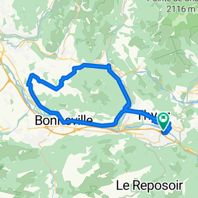
Pnte Blanche Loop
A cycling route starting in Scionzier, Auvergne-Rhône-Alpes, France.
Overview
About this route
Near 3000m total climb over just 80 km, with about 15km over 10% and points (on the Sommet d'Andey) around 18%-20%.
Quiet roads, little traffic, nice mountains views.
- -:--
- Duration
- 85.7 km
- Distance
- 2,062 m
- Ascent
- 2,062 m
- Descent
- ---
- Avg. speed
- ---
- Max. altitude
Route quality
Waytypes & surfaces along the route
Waytypes
Road
22.3 km
(26 %)
Quiet road
18.9 km
(22 %)
Surfaces
Paved
42 km
(49 %)
Unpaved
3.4 km
(4 %)
Asphalt
42 km
(49 %)
Unpaved (undefined)
1.7 km
(2 %)
Continue with Bikemap
Use, edit, or download this cycling route
You would like to ride Pnte Blanche Loop or customize it for your own trip? Here is what you can do with this Bikemap route:
Free features
- Save this route as favorite or in collections
- Copy & plan your own version of this route
- Split it into stages to create a multi-day tour
- Sync your route with Garmin or Wahoo
Premium features
Free trial for 3 days, or one-time payment. More about Bikemap Premium.
- Navigate this route on iOS & Android
- Export a GPX / KML file of this route
- Create your custom printout (try it for free)
- Download this route for offline navigation
Discover more Premium features.
Get Bikemap PremiumFrom our community
Other popular routes starting in Scionzier
 Alpes 1
- Distance
- 103.8 km
- Ascent
- 2,412 m
- Descent
- 2,560 m
- Location
- Scionzier, Auvergne-Rhône-Alpes, France
 Pnte Blanche Loop
- Distance
- 85.7 km
- Ascent
- 2,062 m
- Descent
- 2,062 m
- Location
- Scionzier, Auvergne-Rhône-Alpes, France
 Cluses J4 Cyclos
- Distance
- 48.9 km
- Ascent
- 459 m
- Descent
- 458 m
- Location
- Scionzier, Auvergne-Rhône-Alpes, France
 Col de Colombière both side and Col de Romme
- Distance
- 66.3 km
- Ascent
- 2,103 m
- Descent
- 2,107 m
- Location
- Scionzier, Auvergne-Rhône-Alpes, France
 Cluses J3 Cyclos
- Distance
- 107.3 km
- Ascent
- 1,191 m
- Descent
- 1,191 m
- Location
- Scionzier, Auvergne-Rhône-Alpes, France
 Cluses J2 Cyclos
- Distance
- 91.9 km
- Ascent
- 1,695 m
- Descent
- 1,697 m
- Location
- Scionzier, Auvergne-Rhône-Alpes, France
 Fra - day 2_po dolini
- Distance
- 45.4 km
- Ascent
- 1,151 m
- Descent
- 168 m
- Location
- Scionzier, Auvergne-Rhône-Alpes, France
 Col de Colombière both side and Col de Romme
- Distance
- 66.3 km
- Ascent
- 2,100 m
- Descent
- 2,103 m
- Location
- Scionzier, Auvergne-Rhône-Alpes, France
Open it in the app