
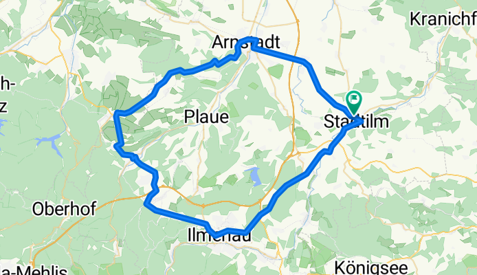
Stadtilm - Jonastal - Gräfenroda - Ilmenau - Stadtilm
A cycling route starting in Stadtilm, Free State of Thuringia, Germany.
Overview
About this route
Diese Tour verläuft überwiegend noch auf guten Straßen (teilweise Arnstadt/Jonastal sanierungsbedürftig). Sie ist in beiden Richtungen reizvoll. Entgegen Uhrzeigersinn ist der sanfte Daueranstieg im Jonastal sehr angenehmen. Die 88n von Gräfenroda nach Elgersburg ist hinter der Bahnunterführung ein kleiner Kraftakt.
Ab Elgersburg geht es dann gemütlich bis Stadtilm ohne große Herausforderung.
Nur in Arnstadt und Ilmenau wirken einige Ampeln bremsend. In Frankenhain gibt es eine Wechselspurampel an einer Engstelle.
- -:--
- Duration
- 63.9 km
- Distance
- 535 m
- Ascent
- 535 m
- Descent
- ---
- Avg. speed
- ---
- Max. altitude
Continue with Bikemap
Use, edit, or download this cycling route
You would like to ride Stadtilm - Jonastal - Gräfenroda - Ilmenau - Stadtilm or customize it for your own trip? Here is what you can do with this Bikemap route:
Free features
- Save this route as favorite or in collections
- Copy & plan your own version of this route
- Sync your route with Garmin or Wahoo
Premium features
Free trial for 3 days, or one-time payment. More about Bikemap Premium.
- Navigate this route on iOS & Android
- Export a GPX / KML file of this route
- Create your custom printout (try it for free)
- Download this route for offline navigation
Discover more Premium features.
Get Bikemap PremiumFrom our community
Other popular routes starting in Stadtilm
 Stadtilm - Großkochberg
- Distance
- 59.1 km
- Ascent
- 537 m
- Descent
- 540 m
- Location
- Stadtilm, Free State of Thuringia, Germany
 Stadtilm Jena
- Distance
- 67.2 km
- Ascent
- 255 m
- Descent
- 476 m
- Location
- Stadtilm, Free State of Thuringia, Germany
 Stadtilm - Kleinhettstedt - Straußenfarm 04.09.2021
- Distance
- 9.5 km
- Ascent
- 82 m
- Descent
- 84 m
- Location
- Stadtilm, Free State of Thuringia, Germany
 Paulinzella
- Distance
- 12 km
- Ascent
- 156 m
- Descent
- 181 m
- Location
- Stadtilm, Free State of Thuringia, Germany
 Kleinliebringen 20, Stadtilm nach L1106 10, Kaulsdorf
- Distance
- 35.2 km
- Ascent
- 376 m
- Descent
- 560 m
- Location
- Stadtilm, Free State of Thuringia, Germany
 Ilm 1 (Stadtilm-Ilmursprung-Ilmenau)
- Distance
- 42.2 km
- Ascent
- 313 m
- Descent
- 197 m
- Location
- Stadtilm, Free State of Thuringia, Germany
 Stadtilm - Stausee Hohenfelden 21.08.2021
- Distance
- 37.8 km
- Ascent
- 434 m
- Descent
- 471 m
- Location
- Stadtilm, Free State of Thuringia, Germany
 Rinnetal - SaaleRadweg bis Jena
- Distance
- 70.3 km
- Ascent
- 195 m
- Descent
- 488 m
- Location
- Stadtilm, Free State of Thuringia, Germany
Open it in the app