

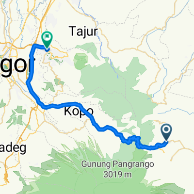
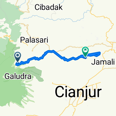
Pjok 1
A cycling route starting in Cianjur, West Java, Indonesia.
Overview
About this route
- 1 h 8 min
- Duration
- 17.8 km
- Distance
- 193 m
- Ascent
- 199 m
- Descent
- 15.7 km/h
- Avg. speed
- ---
- Max. altitude
Rasyiiq Ariq

created this 4 years ago
Route photos


Route quality
Waytypes & surfaces along the route
Waytypes
Cycleway
4.6 km
(26 %)
Road
4.1 km
(23 %)
Surfaces
Paved
5.9 km
(33 %)
Asphalt
5.9 km
(33 %)
Undefined
11.9 km
(67 %)
Continue with Bikemap
Use, edit, or download this cycling route
You would like to ride Pjok 1 or customize it for your own trip? Here is what you can do with this Bikemap route:
Free features
- Save this route as favorite or in collections
- Copy & plan your own version of this route
- Sync your route with Garmin or Wahoo
Premium features
Free trial for 3 days, or one-time payment. More about Bikemap Premium.
- Navigate this route on iOS & Android
- Export a GPX / KML file of this route
- Create your custom printout (try it for free)
- Download this route for offline navigation
Discover more Premium features.
Get Bikemap PremiumFrom our community
Other popular routes starting in Cianjur
- kota bunga sentul
- 42.9 km
- 486 m
- 1,302 m
- Cianjur, West Java, Indonesia
- 2) Cianjur - Bandung
- 66.6 km
- 853 m
- 610 m
- Cianjur, West Java, Indonesia
- Gunung Padang (mini loop)
- 61.4 km
- 789 m
- 789 m
- Cianjur, West Java, Indonesia
- Java-Bali 02, Indonesia, Cipanas - Garut, 149
- 149.3 km
- 1,063 m
- 1,456 m
- Cianjur, West Java, Indonesia
- Aquila Track
- 34.1 km
- 651 m
- 1,563 m
- Cianjur, West Java, Indonesia
- Cipendawa, Kecamatan Pacet to Jalan Taman Udayana I 58, Kecamatan Babakan Madang
- 52.4 km
- 698 m
- 1,539 m
- Cianjur, West Java, Indonesia
- Jalan Cigalumpit Regency 23, Karangtengah to Jalan Halteu Maleber 52, Karangtengah
- 18.3 km
- 214 m
- 234 m
- Cianjur, West Java, Indonesia


Open it in the app