

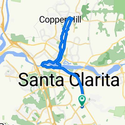
SCV Bike Path Loop
A cycling route starting in Santa Clarita, California, United States.
Overview
About this route
- 2 h 4 min
- Duration
- 36.7 km
- Distance
- 245 m
- Ascent
- 245 m
- Descent
- 17.7 km/h
- Avg. speed
- ---
- Max. altitude
Route quality
Waytypes & surfaces along the route
Waytypes
Cycleway
31.5 km
(86 %)
Quiet road
2.2 km
(6 %)
Surfaces
Paved
32.6 km
(89 %)
Paved (undefined)
16.9 km
(46 %)
Asphalt
14.7 km
(40 %)
Continue with Bikemap
Use, edit, or download this cycling route
You would like to ride SCV Bike Path Loop or customize it for your own trip? Here is what you can do with this Bikemap route:
Free features
- Save this route as favorite or in collections
- Copy & plan your own version of this route
- Sync your route with Garmin or Wahoo
Premium features
Free trial for 3 days, or one-time payment. More about Bikemap Premium.
- Navigate this route on iOS & Android
- Export a GPX / KML file of this route
- Create your custom printout (try it for free)
- Download this route for offline navigation
Discover more Premium features.
Get Bikemap PremiumFrom our community
Other popular routes starting in Santa Clarita
 De Glasser Avenue 27533, Santa Clarita a Sierra Highway 27361, Santa Clarita
- Distance
- 4.4 km
- Ascent
- 4 m
- Descent
- 0 m
- Location
- Santa Clarita, California, United States
 Long Evening Course In Stevenson Ranch
- Distance
- 20.2 km
- Ascent
- 0 m
- Descent
- 0 m
- Location
- Santa Clarita, California, United States
 mud
mud- Distance
- 18.6 km
- Ascent
- 389 m
- Descent
- 397 m
- Location
- Santa Clarita, California, United States
 S Fork River Trail, Santa Clarita a Princessa, Santa Clarita
- Distance
- 22 km
- Ascent
- 265 m
- Descent
- 267 m
- Location
- Santa Clarita, California, United States
 Oak Terrace Place 26507, Stevenson Ranch to Pico Canyon Service Road, Stevenson Ranch
- Distance
- 10.4 km
- Ascent
- 192 m
- Descent
- 64 m
- Location
- Santa Clarita, California, United States
 Dec 14, 2014, 12:06 PM
- Distance
- 40.3 km
- Ascent
- 277 m
- Descent
- 277 m
- Location
- Santa Clarita, California, United States
 Chayden pick up a 6:40
- Distance
- 15.8 km
- Ascent
- 130 m
- Descent
- 129 m
- Location
- Santa Clarita, California, United States
 Soledad Canyon Rd to Discovery Park
- Distance
- 8.3 km
- Ascent
- 41 m
- Descent
- 41 m
- Location
- Santa Clarita, California, United States
Open it in the app