
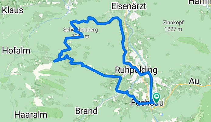
D_Bayern-Fuchsau-Gstatt-Steinbachalm-HochfellnMittelstation-Scheichenbergalm-MariaEckWeg-Dießelbachweg-ChiemgauCoaster-Ruhpolding_RR-26km-650hm
A cycling route starting in Ruhpolding, Bavaria, Germany.
Overview
About this route
- -:--
- Duration
- 26.1 km
- Distance
- 613 m
- Ascent
- 613 m
- Descent
- ---
- Avg. speed
- 1,079 m
- Max. altitude

Continue with Bikemap
Use, edit, or download this cycling route
You would like to ride D_Bayern-Fuchsau-Gstatt-Steinbachalm-HochfellnMittelstation-Scheichenbergalm-MariaEckWeg-Dießelbachweg-ChiemgauCoaster-Ruhpolding_RR-26km-650hm or customize it for your own trip? Here is what you can do with this Bikemap route:
Free features
- Save this route as favorite or in collections
- Copy & plan your own version of this route
- Sync your route with Garmin or Wahoo
Premium features
Free trial for 3 days, or one-time payment. More about Bikemap Premium.
- Navigate this route on iOS & Android
- Export a GPX / KML file of this route
- Create your custom printout (try it for free)
- Download this route for offline navigation
Discover more Premium features.
Get Bikemap PremiumFrom our community
Other popular routes starting in Ruhpolding
 Ruhpolding-Dandl Alm-Jochberg Alm-Ruhpolding CLONED FROM ROUTE 1704365
- Distance
- 37.9 km
- Ascent
- 684 m
- Descent
- 686 m
- Location
- Ruhpolding, Bavaria, Germany
 Rauschbergrunde
- Distance
- 26.4 km
- Ascent
- 588 m
- Descent
- 588 m
- Location
- Ruhpolding, Bavaria, Germany
 Hochfellnrunde
- Distance
- 56.9 km
- Ascent
- 1,224 m
- Descent
- 1,228 m
- Location
- Ruhpolding, Bavaria, Germany
 Röthelmoosalm
- Distance
- 54.2 km
- Ascent
- 1,396 m
- Descent
- 1,398 m
- Location
- Ruhpolding, Bavaria, Germany
 Rund um den Hochfelln
- Distance
- 27 km
- Ascent
- 851 m
- Descent
- 854 m
- Location
- Ruhpolding, Bavaria, Germany
 HIPP-Trophy
- Distance
- 1.3 km
- Ascent
- 30 m
- Descent
- 30 m
- Location
- Ruhpolding, Bavaria, Germany
 Rund ums Sonntagshorn
- Distance
- 44.5 km
- Ascent
- 1,040 m
- Descent
- 1,032 m
- Location
- Ruhpolding, Bavaria, Germany
 Jochbergalm
- Distance
- 19.7 km
- Ascent
- 660 m
- Descent
- 656 m
- Location
- Ruhpolding, Bavaria, Germany
Open it in the app