

The Lazyboi but fun Route by Gajen
A cycling route starting in Besançon, Bourgogne-Franche-Comté, France.
Overview
About this route
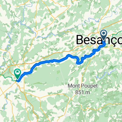
Its a fun bike route that starts at the Pont battant. which then leads to the gare d'eau. After a enjoyable ride along the river it leads to an underground tunnel that is a shortcut for the river to cut through. This is a special short fun route because it starts an urban zone and it ends out in the forest. you see multiple locks for barges along the way n it ends with a challenging ride through a tight pathway where any mistake could leave you battered at the bottom of the doubs....MUAHAHAHAHAHAHAHA...just kidding
- -:--
- Duration
- 4.6 km
- Distance
- 164 m
- Ascent
- 166 m
- Descent
- ---
- Avg. speed
- ---
- Max. altitude

Continue with Bikemap
Use, edit, or download this cycling route
You would like to ride The Lazyboi but fun Route by Gajen or customize it for your own trip? Here is what you can do with this Bikemap route:
Free features
- Save this route as favorite or in collections
- Copy & plan your own version of this route
- Sync your route with Garmin or Wahoo
Premium features
Free trial for 3 days, or one-time payment. More about Bikemap Premium.
- Navigate this route on iOS & Android
- Export a GPX / KML file of this route
- Create your custom printout (try it for free)
- Download this route for offline navigation
Discover more Premium features.
Get Bikemap PremiumFrom our community
Other popular routes starting in Besançon
 C60+3_Besançon-Varia_Arc_en_Senans-Sampans_Bikemap_81_779
- Distance
- 75.3 km
- Ascent
- 757 m
- Descent
- 836 m
- Location
- Besançon, Bourgogne-Franche-Comté, France
 Besancon - Chalon-sur-Saone
- Distance
- 154.5 km
- Ascent
- 613 m
- Descent
- 675 m
- Location
- Besançon, Bourgogne-Franche-Comté, France
 Vennans 50km
- Distance
- 50.9 km
- Ascent
- 489 m
- Descent
- 489 m
- Location
- Besançon, Bourgogne-Franche-Comté, France
 C60+3_Cit_Besançon-Arc_en_Senans-Sampans_Bikemap_81_779
- Distance
- 81.4 km
- Ascent
- 779 m
- Descent
- 854 m
- Location
- Besançon, Bourgogne-Franche-Comté, France
 Besançon - Seurre
- Distance
- 90.5 km
- Ascent
- 544 m
- Descent
- 611 m
- Location
- Besançon, Bourgogne-Franche-Comté, France
 Avenue Elisée Cusenier nach Route nationale
- Distance
- 64.4 km
- Ascent
- 468 m
- Descent
- 501 m
- Location
- Besançon, Bourgogne-Franche-Comté, France
 VTT114
- Distance
- 27.2 km
- Ascent
- 498 m
- Descent
- 497 m
- Location
- Besançon, Bourgogne-Franche-Comté, France
 Deutschland - Portugal (Berlin - Faro) FR 10 Besançon - Orchamps
- Distance
- 44.2 km
- Ascent
- 306 m
- Descent
- 306 m
- Location
- Besançon, Bourgogne-Franche-Comté, France
Open it in the app