

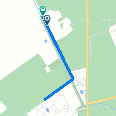
Szegfű utca 1, Kunfehértó to Arany János utca 4, Jánoshalma
A cycling route starting in Kunfehértó, Bács-Kiskun county, Hungary.
Overview
About this route
- 44 min
- Duration
- 15 km
- Distance
- 10 m
- Ascent
- 9 m
- Descent
- 20.5 km/h
- Avg. speed
- ---
- Max. altitude

Route quality
Waytypes & surfaces along the route
Waytypes
Cycleway
2.4 km
(16 %)
Quiet road
1.8 km
(12 %)
Surfaces
Paved
13.8 km
(92 %)
Asphalt
13.8 km
(92 %)
Undefined
1.2 km
(8 %)
Continue with Bikemap
Use, edit, or download this cycling route
You would like to ride Szegfű utca 1, Kunfehértó to Arany János utca 4, Jánoshalma or customize it for your own trip? Here is what you can do with this Bikemap route:
Free features
- Save this route as favorite or in collections
- Copy & plan your own version of this route
- Sync your route with Garmin or Wahoo
Premium features
Free trial for 3 days, or one-time payment. More about Bikemap Premium.
- Navigate this route on iOS & Android
- Export a GPX / KML file of this route
- Create your custom printout (try it for free)
- Download this route for offline navigation
Discover more Premium features.
Get Bikemap PremiumFrom our community
Other popular routes starting in Kunfehértó
 90km
90km- Distance
- 85.8 km
- Ascent
- 92 m
- Descent
- 95 m
- Location
- Kunfehértó, Bács-Kiskun county, Hungary
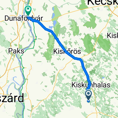 Kunfehértó - Dunaföldvár
- Distance
- 76.9 km
- Ascent
- 70 m
- Descent
- 108 m
- Location
- Kunfehértó, Bács-Kiskun county, Hungary
 TERV Kunfehértó - Ósükösd (Kéktúra)
- Distance
- 72 km
- Ascent
- 109 m
- Descent
- 161 m
- Location
- Kunfehértó, Bács-Kiskun county, Hungary
 000000
- Distance
- 39.6 km
- Ascent
- 16 m
- Descent
- 18 m
- Location
- Kunfehértó, Bács-Kiskun county, Hungary
 mimimum
- Distance
- 2 km
- Ascent
- 16 m
- Descent
- 51 m
- Location
- Kunfehértó, Bács-Kiskun county, Hungary
 július 9
- Distance
- 55.4 km
- Ascent
- 33 m
- Descent
- 85 m
- Location
- Kunfehértó, Bács-Kiskun county, Hungary
 Folyamatos utazás
- Distance
- 15.7 km
- Ascent
- 72 m
- Descent
- 74 m
- Location
- Kunfehértó, Bács-Kiskun county, Hungary
 július 9
- Distance
- 62.3 km
- Ascent
- 59 m
- Descent
- 97 m
- Location
- Kunfehértó, Bács-Kiskun county, Hungary
Open it in the app