

Ruta Mariquita el Campanario
A cycling route starting in Mariquita, Tolima Department, Colombia.
Overview
About this route
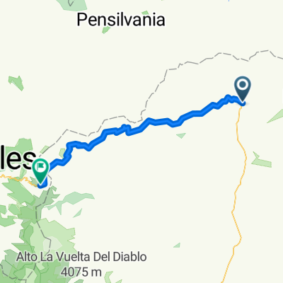
Route on a dirt road with a good incline but it reaches a flat section to allow turning back through the south of Mariquita.
- -:--
- Duration
- 5.7 km
- Distance
- 327 m
- Ascent
- 16 m
- Descent
- ---
- Avg. speed
- ---
- Max. altitude
Continue with Bikemap
Use, edit, or download this cycling route
You would like to ride Ruta Mariquita el Campanario or customize it for your own trip? Here is what you can do with this Bikemap route:
Free features
- Save this route as favorite or in collections
- Copy & plan your own version of this route
- Sync your route with Garmin or Wahoo
Premium features
Free trial for 3 days, or one-time payment. More about Bikemap Premium.
- Navigate this route on iOS & Android
- Export a GPX / KML file of this route
- Create your custom printout (try it for free)
- Download this route for offline navigation
Discover more Premium features.
Get Bikemap PremiumFrom our community
Other popular routes starting in Mariquita
 De Carrera 15 C 6-39, Mariquita a Calle 5ª 1403, Mariquita
- Distance
- 26.9 km
- Ascent
- 0 m
- Descent
- 41 m
- Location
- Mariquita, Tolima Department, Colombia
 MARIQUITA
- Distance
- 272.5 km
- Ascent
- 3,195 m
- Descent
- 1,795 m
- Location
- Mariquita, Tolima Department, Colombia
 Mariquita - Murillo
- Distance
- 185.9 km
- Ascent
- 8,100 m
- Descent
- 5,071 m
- Location
- Mariquita, Tolima Department, Colombia
 , Mariquita a Padua-Letras
- Distance
- 75.6 km
- Ascent
- 4,128 m
- Descent
- 1,084 m
- Location
- Mariquita, Tolima Department, Colombia
 De Mariquita peaje, peaje a Mariquita
- Distance
- 17.7 km
- Ascent
- 176 m
- Descent
- 179 m
- Location
- Mariquita, Tolima Department, Colombia
 Mariquita - Alto de letras
- Distance
- 81.7 km
- Ascent
- 3,542 m
- Descent
- 346 m
- Location
- Mariquita, Tolima Department, Colombia
 Alto de Letras
- Distance
- 85.5 km
- Ascent
- 3,474 m
- Descent
- 487 m
- Location
- Mariquita, Tolima Department, Colombia
 Mariquita - Páramo De Letras
- Distance
- 80.9 km
- Ascent
- 3,540 m
- Descent
- 343 m
- Location
- Mariquita, Tolima Department, Colombia
Open it in the app