

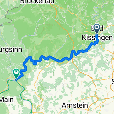
BK-Gradierbau-Saline-Bismarck-Botenlauben-Wittelsbacher Turm-BK
A cycling route starting in Bad Kissingen, Bavaria, Germany.
Overview
About this route
- -:--
- Duration
- 25.5 km
- Distance
- 470 m
- Ascent
- 469 m
- Descent
- ---
- Avg. speed
- 397 m
- Max. altitude

Route quality
Waytypes & surfaces along the route
Waytypes
Quiet road
8.2 km
(32 %)
Track
6.4 km
(25 %)
Surfaces
Paved
15 km
(59 %)
Unpaved
7.1 km
(28 %)
Asphalt
14 km
(55 %)
Loose gravel
3.6 km
(14 %)
Continue with Bikemap
Use, edit, or download this cycling route
You would like to ride BK-Gradierbau-Saline-Bismarck-Botenlauben-Wittelsbacher Turm-BK or customize it for your own trip? Here is what you can do with this Bikemap route:
Free features
- Save this route as favorite or in collections
- Copy & plan your own version of this route
- Sync your route with Garmin or Wahoo
Premium features
Free trial for 3 days, or one-time payment. More about Bikemap Premium.
- Navigate this route on iOS & Android
- Export a GPX / KML file of this route
- Create your custom printout (try it for free)
- Download this route for offline navigation
Discover more Premium features.
Get Bikemap PremiumFrom our community
Other popular routes starting in Bad Kissingen
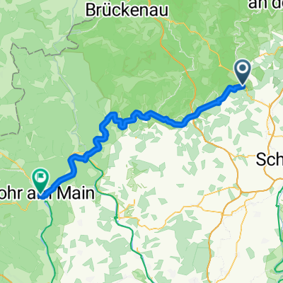 Bad Kissingen - Lohr am Main
- Distance
- 61.5 km
- Ascent
- 615 m
- Descent
- 701 m
- Location
- Bad Kissingen, Bavaria, Germany
 25.04.21 Aura
- Distance
- 26.1 km
- Ascent
- 409 m
- Descent
- 416 m
- Location
- Bad Kissingen, Bavaria, Germany
 Rundweg Bad Bocklet Nüdlingen
- Distance
- 22.9 km
- Ascent
- 351 m
- Descent
- 343 m
- Location
- Bad Kissingen, Bavaria, Germany
 50.213, 10.074 до 50.211, 10.078
- Distance
- 19.9 km
- Ascent
- 176 m
- Descent
- 151 m
- Location
- Bad Kissingen, Bavaria, Germany
 BK-Basaltsäulen Gangolfsberg-BK
- Distance
- 100.7 km
- Ascent
- 444 m
- Descent
- 496 m
- Location
- Bad Kissingen, Bavaria, Germany
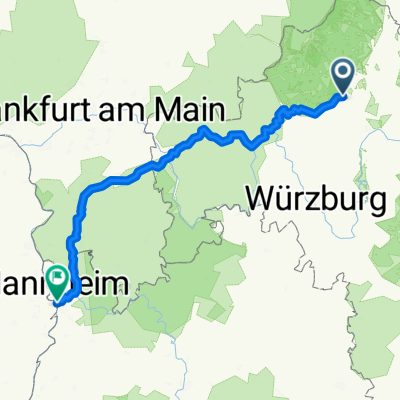 Von Bad Kissingen bis Altrip
- Distance
- 217.2 km
- Ascent
- 2,021 m
- Descent
- 2,178 m
- Location
- Bad Kissingen, Bavaria, Germany
 Jahnstraße, Bad Kissingen nach Baptist-Hoffmann-Straße, Bad Kissingen
- Distance
- 16 km
- Ascent
- 122 m
- Descent
- 116 m
- Location
- Bad Kissingen, Bavaria, Germany
 Bad Kissingen - Gemünden am Main
- Distance
- 52.8 km
- Ascent
- 101 m
- Descent
- 149 m
- Location
- Bad Kissingen, Bavaria, Germany
Open it in the app