

Traseu 1: bicicletă nivel AVANSAT
A cycling route starting in Bogdăneşti, Cluj County, Romania.
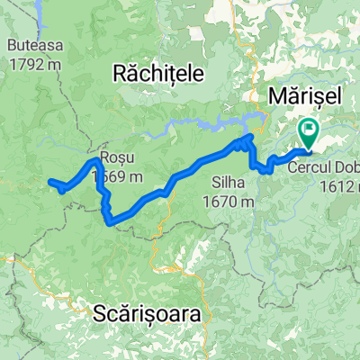
Overview
About this route
- -:--
- Duration
- 61 km
- Distance
- 871 m
- Ascent
- 866 m
- Descent
- ---
- Avg. speed
- 1,617 m
- Max. altitude

Continue with Bikemap
Use, edit, or download this cycling route
You would like to ride Traseu 1: bicicletă nivel AVANSAT or customize it for your own trip? Here is what you can do with this Bikemap route:
Free features
- Save this route as favorite or in collections
- Copy & plan your own version of this route
- Sync your route with Garmin or Wahoo
Premium features
Free trial for 3 days, or one-time payment. More about Bikemap Premium.
- Navigate this route on iOS & Android
- Export a GPX / KML file of this route
- Create your custom printout (try it for free)
- Download this route for offline navigation
Discover more Premium features.
Get Bikemap PremiumFrom our community
Other popular routes starting in Bogdăneşti
 Maguri - Giurcuta - Giurcuta
- Distance
- 54.3 km
- Ascent
- 1,109 m
- Descent
- 1,109 m
- Location
- Bogdăneşti, Cluj County, Romania
 piatra grosilor
- Distance
- 39.9 km
- Ascent
- 550 m
- Descent
- 1,203 m
- Location
- Bogdăneşti, Cluj County, Romania
 TB Tina Bogdanului Sacel
- Distance
- 42.8 km
- Ascent
- 578 m
- Descent
- 1,518 m
- Location
- Bogdăneşti, Cluj County, Romania
 maguri racatau circuit
- Distance
- 26 km
- Ascent
- 908 m
- Descent
- 963 m
- Location
- Bogdăneşti, Cluj County, Romania
 Maguri-Racatau
- Distance
- 61.7 km
- Ascent
- 1,126 m
- Descent
- 1,125 m
- Location
- Bogdăneşti, Cluj County, Romania
 La ciolit cu motoreta de la 12-19 h
- Distance
- 68.4 km
- Ascent
- 1,449 m
- Descent
- 1,457 m
- Location
- Bogdăneşti, Cluj County, Romania
 Maguri - Padis - Maguri
- Distance
- 110.8 km
- Ascent
- 1,601 m
- Descent
- 1,601 m
- Location
- Bogdăneşti, Cluj County, Romania
 Maguri - MTB
- Distance
- 32.8 km
- Ascent
- 0 m
- Descent
- 0 m
- Location
- Bogdăneşti, Cluj County, Romania
Open it in the app