

PonikveDragatus2021
A cycling route starting in Trebnje, Trebnje, Slovenia.
Overview
About this route
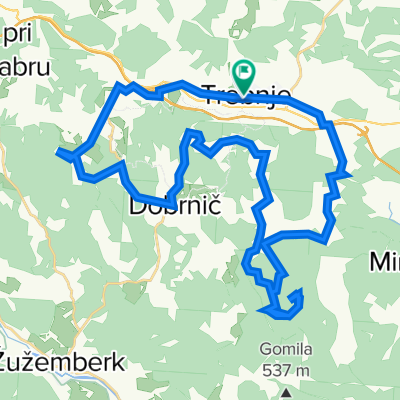
Gorenje Ponikve-Dolenje Ponikve-Biška Vas-Mirna Peč-Vrhovo pri Mirni Peči-(pred Prečna zavijemo desno)-Podgora-Straža (prečkamo reko Krko)-Vavta Vas-(mimo Straško brezno)-Uršna Sela (cesta 664 ob železnici)-Laze-ŽP Rožni dol-Preloge-(pridemo na cesto 216-Partizanska magistrala iz smeri Čermošnjice; blizu je ŽP Semič)-Ručetna vas-Lokve(pot št. 2)-Črnomelj-(ob Lahinji; pot št 4))-Butoraj-Velika Lahinja-Brdarci-Podlog-Dragatuš (60 km)
- -:--
- Duration
- 59.8 km
- Distance
- 713 m
- Ascent
- 757 m
- Descent
- ---
- Avg. speed
- 454 m
- Max. altitude

Route quality
Waytypes & surfaces along the route
Waytypes
Quiet road
31.7 km
(53 %)
Road
22.7 km
(38 %)
Undefined
5.4 km
(9 %)
Surfaces
Paved
42.5 km
(71 %)
Asphalt
42.5 km
(71 %)
Undefined
17.3 km
(29 %)
Continue with Bikemap
Use, edit, or download this cycling route
You would like to ride PonikveDragatus2021 or customize it for your own trip? Here is what you can do with this Bikemap route:
Free features
- Save this route as favorite or in collections
- Copy & plan your own version of this route
- Sync your route with Garmin or Wahoo
Premium features
Free trial for 3 days, or one-time payment. More about Bikemap Premium.
- Navigate this route on iOS & Android
- Export a GPX / KML file of this route
- Create your custom printout (try it for free)
- Download this route for offline navigation
Discover more Premium features.
Get Bikemap PremiumFrom our community
Other popular routes starting in Trebnje
 Trebnje Dana 20.junij
- Distance
- 63.9 km
- Ascent
- 334 m
- Descent
- 336 m
- Location
- Trebnje, Trebnje, Slovenia
 Kozjak, Ostri vrh
- Distance
- 43.8 km
- Ascent
- 820 m
- Descent
- 820 m
- Location
- Trebnje, Trebnje, Slovenia
 Trebnje Šmarješke toplice Žužemberk Trebnje
- Distance
- 63.1 km
- Ascent
- 433 m
- Descent
- 433 m
- Location
- Trebnje, Trebnje, Slovenia
 trebnje-trebeljevo-grosuplje-trebnje
- Distance
- 80.8 km
- Ascent
- 808 m
- Descent
- 798 m
- Location
- Trebnje, Trebnje, Slovenia
 trebnje-mirna peč
- Distance
- 40 km
- Ascent
- 620 m
- Descent
- 619 m
- Location
- Trebnje, Trebnje, Slovenia
 Trebnje - Otočec - Straža - Mirna Peč -Trebnje
- Distance
- 68 km
- Ascent
- 557 m
- Descent
- 557 m
- Location
- Trebnje, Trebnje, Slovenia
 trebnje, mirna peč, vrhovo, straža, prečna, trebnje
- Distance
- 46.5 km
- Ascent
- 406 m
- Descent
- 406 m
- Location
- Trebnje, Trebnje, Slovenia
 Trebnje-Šentrupert-Dole pri Litiji-Gabrovka-Čatež-Trebnje
- Distance
- 47 km
- Ascent
- 724 m
- Descent
- 722 m
- Location
- Trebnje, Trebnje, Slovenia
Open it in the app