

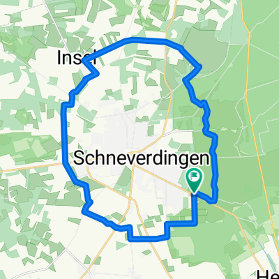
Wd09-Osterheide-Wilseder-Berg-35km
A cycling route starting in Schneverdingen, Lower Saxony, Germany.
Overview
About this route
- -:--
- Duration
- 35.4 km
- Distance
- 193 m
- Ascent
- 193 m
- Descent
- ---
- Avg. speed
- 165 m
- Max. altitude

Route quality
Waytypes & surfaces along the route
Waytypes
Track
22.3 km
(63 %)
Quiet road
8.1 km
(23 %)
Surfaces
Paved
7.1 km
(20 %)
Unpaved
24 km
(68 %)
Gravel
16.6 km
(47 %)
Paved (undefined)
3.9 km
(11 %)
Route highlights
Points of interest along the route
Point of interest after 4.3 km
Silvestersee, Osterheide
Point of interest after 11.1 km
Niederhaverbeck, Bienenwelten
Point of interest after 12.5 km
Heidetal (Gehöft)
Point of interest after 14.3 km
Willseder Berg, 169m
Point of interest after 15.9 km
Wilsede, Dat ole Huus (Heimatmuseum)
Point of interest after 22.3 km
Wulfsberg
Point of interest after 23.6 km
Hof Tütsberg
Point of interest after 29 km
B3
Point of interest after 29.7 km
Hof Möhr, Osterheide
Continue with Bikemap
Use, edit, or download this cycling route
You would like to ride Wd09-Osterheide-Wilseder-Berg-35km or customize it for your own trip? Here is what you can do with this Bikemap route:
Free features
- Save this route as favorite or in collections
- Copy & plan your own version of this route
- Sync your route with Garmin or Wahoo
Premium features
Free trial for 3 days, or one-time payment. More about Bikemap Premium.
- Navigate this route on iOS & Android
- Export a GPX / KML file of this route
- Create your custom printout (try it for free)
- Download this route for offline navigation
Discover more Premium features.
Get Bikemap PremiumFrom our community
Other popular routes starting in Schneverdingen
 Heber 14 km
- Distance
- 14 km
- Ascent
- 44 m
- Descent
- 37 m
- Location
- Schneverdingen, Lower Saxony, Germany
 Durch die Heide
- Distance
- 42.1 km
- Ascent
- 182 m
- Descent
- 180 m
- Location
- Schneverdingen, Lower Saxony, Germany
 13.10.13
- Distance
- 43.5 km
- Ascent
- 216 m
- Descent
- 218 m
- Location
- Schneverdingen, Lower Saxony, Germany
 02-Schneverdingen-Hitzacker-102km
- Distance
- 101.3 km
- Ascent
- 608 m
- Descent
- 679 m
- Location
- Schneverdingen, Lower Saxony, Germany
 heide
heide- Distance
- 47.5 km
- Ascent
- 192 m
- Descent
- 191 m
- Location
- Schneverdingen, Lower Saxony, Germany
 4_TourRundumSchneverdingen
- Distance
- 22.3 km
- Ascent
- 76 m
- Descent
- 76 m
- Location
- Schneverdingen, Lower Saxony, Germany
 Melkhus Fintel
- Distance
- 28 km
- Ascent
- 58 m
- Descent
- 55 m
- Location
- Schneverdingen, Lower Saxony, Germany
 Tag 2 Schneverdingen-Fintel
- Distance
- 35 km
- Ascent
- 81 m
- Descent
- 84 m
- Location
- Schneverdingen, Lower Saxony, Germany
Open it in the app