

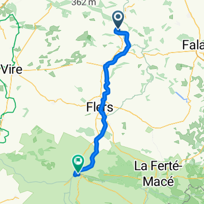
Recovered Route
A cycling route starting in Saint-Rémy, Normandy, France.
Overview
About this route
- 1 h 6 min
- Duration
- 16.3 km
- Distance
- 133 m
- Ascent
- 145 m
- Descent
- 14.8 km/h
- Avg. speed
- ---
- Max. altitude
Route quality
Waytypes & surfaces along the route
Waytypes
Path
16.1 km
(99 %)
Pedestrian area
0.2 km
(1 %)
Surfaces
Paved
16.1 km
(99 %)
Asphalt
16.1 km
(99 %)
Undefined
0.2 km
(1 %)
Continue with Bikemap
Use, edit, or download this cycling route
You would like to ride Recovered Route or customize it for your own trip? Here is what you can do with this Bikemap route:
Free features
- Save this route as favorite or in collections
- Copy & plan your own version of this route
- Sync your route with Garmin or Wahoo
Premium features
Free trial for 3 days, or one-time payment. More about Bikemap Premium.
- Navigate this route on iOS & Android
- Export a GPX / KML file of this route
- Create your custom printout (try it for free)
- Download this route for offline navigation
Discover more Premium features.
Get Bikemap PremiumFrom our community
Other popular routes starting in Saint-Rémy
 Route from Saint-Rémy
- Distance
- 55.2 km
- Ascent
- 713 m
- Descent
- 589 m
- Location
- Saint-Rémy, Normandy, France
 Domfront
- Distance
- 54.1 km
- Ascent
- 708 m
- Descent
- 574 m
- Location
- Saint-Rémy, Normandy, France
 Pont de la Mousse / Ouistreham
- Distance
- 48.5 km
- Ascent
- 190 m
- Descent
- 234 m
- Location
- Saint-Rémy, Normandy, France
 De Route de Thury Harcourt, Saint-Rémy à 32 Route de Condé, Saint-Rémy
- Distance
- 1.2 km
- Ascent
- 6 m
- Descent
- 3 m
- Location
- Saint-Rémy, Normandy, France
 De Les Rivières 5, Saint-Remy à Rue Charles Benoist 1, Courseulles-sur-Mer
- Distance
- 116.6 km
- Ascent
- 1,361 m
- Descent
- 1,379 m
- Location
- Saint-Rémy, Normandy, France
 Vallées et panoramas de la Suisse normande – Liaison Culey‑le‑Patry (Saint‑Rémy)
- Distance
- 2.9 km
- Ascent
- 60 m
- Descent
- 63 m
- Location
- Saint-Rémy, Normandy, France
 Itinéraire modéré en Saint-Rémy
- Distance
- 20.4 km
- Ascent
- 211 m
- Descent
- 211 m
- Location
- Saint-Rémy, Normandy, France
 Itinéraire vers Square Saint-Pierre de Donnétal, Caen
- Distance
- 33.9 km
- Ascent
- 77 m
- Descent
- 89 m
- Location
- Saint-Rémy, Normandy, France
Open it in the app