

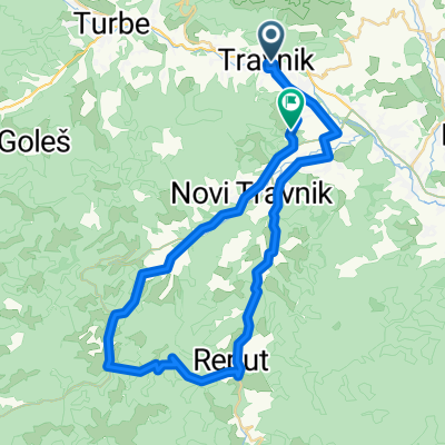
Vlašić, Travnik-Galica-Babanovac-Gostilj-Travnik
A cycling route starting in Travnik, Federation of Bosnia and Herzegovina, Bosnia and Herzegovina.
Overview
About this route
- -:--
- Duration
- 46.8 km
- Distance
- 1,125 m
- Ascent
- 1,125 m
- Descent
- ---
- Avg. speed
- ---
- Max. altitude

Route highlights
Points of interest along the route
Photo after 20.6 km
Skakaonica - predivan vidik
Point of interest after 31.4 km
Roštilj !
Point of interest after 32.1 km
Odavde ide spust
Point of interest after 41.2 km
Uključenje na glavni put za Travnik. voziti u koloni po jedan.
Continue with Bikemap
Use, edit, or download this cycling route
You would like to ride Vlašić, Travnik-Galica-Babanovac-Gostilj-Travnik or customize it for your own trip? Here is what you can do with this Bikemap route:
Free features
- Save this route as favorite or in collections
- Copy & plan your own version of this route
- Sync your route with Garmin or Wahoo
Premium features
Free trial for 3 days, or one-time payment. More about Bikemap Premium.
- Navigate this route on iOS & Android
- Export a GPX / KML file of this route
- Create your custom printout (try it for free)
- Download this route for offline navigation
Discover more Premium features.
Get Bikemap PremiumFrom our community
Other popular routes starting in Travnik
 Dolac -Galica- Paljenik - Preoška-Dub-H.Bila
- Distance
- 52.5 km
- Ascent
- 1,422 m
- Descent
- 1,385 m
- Location
- Travnik, Federation of Bosnia and Herzegovina, Bosnia and Herzegovina
 XCM VLASIC '19 BK Tempo Veelika
- Distance
- 74.9 km
- Ascent
- 1,878 m
- Descent
- 1,879 m
- Location
- Travnik, Federation of Bosnia and Herzegovina, Bosnia and Herzegovina
 Bosna T2 - Vlašič
- Distance
- 93.4 km
- Ascent
- 2,262 m
- Descent
- 2,410 m
- Location
- Travnik, Federation of Bosnia and Herzegovina, Bosnia and Herzegovina
 Tr-Boca
- Distance
- 30 km
- Ascent
- 144 m
- Descent
- 144 m
- Location
- Travnik, Federation of Bosnia and Herzegovina, Bosnia and Herzegovina
 Travnik-Dolac na Lašvi-Pokrajčići-Guča Gora-Mosor-Travnik
- Distance
- 26.7 km
- Ascent
- 391 m
- Descent
- 440 m
- Location
- Travnik, Federation of Bosnia and Herzegovina, Bosnia and Herzegovina
 Travnik - Vlašić
- Distance
- 51.7 km
- Ascent
- 1,123 m
- Descent
- 1,123 m
- Location
- Travnik, Federation of Bosnia and Herzegovina, Bosnia and Herzegovina
 Travnik - Vlašić
- Distance
- 48.4 km
- Ascent
- 1,430 m
- Descent
- 1,430 m
- Location
- Travnik, Federation of Bosnia and Herzegovina, Bosnia and Herzegovina
 Travnik-Opara-Rostovo-Travnik
- Distance
- 52.3 km
- Ascent
- 1,416 m
- Descent
- 1,369 m
- Location
- Travnik, Federation of Bosnia and Herzegovina, Bosnia and Herzegovina
Open it in the app