
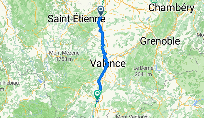
Ile du Beurre - Montélimar (FR-MA9)
A cycling route starting in Condrieu, Auvergne-Rhône-Alpes, France.
Overview
About this route
Ile du Beurre - Montélimar (FR-MA9)
Freiburg - Marseille Stage 9
- -:--
- Duration
- 160 km
- Distance
- 35 m
- Ascent
- 111 m
- Descent
- ---
- Avg. speed
- 148 m
- Max. altitude
Route quality
Waytypes & surfaces along the route
Waytypes
Cycleway
83.2 km
(52 %)
Quiet road
35.2 km
(22 %)
Surfaces
Paved
107.2 km
(67 %)
Unpaved
9.6 km
(6 %)
Asphalt
105.6 km
(66 %)
Gravel
6.4 km
(4 %)
Continue with Bikemap
Use, edit, or download this cycling route
You would like to ride Ile du Beurre - Montélimar (FR-MA9) or customize it for your own trip? Here is what you can do with this Bikemap route:
Free features
- Save this route as favorite or in collections
- Copy & plan your own version of this route
- Split it into stages to create a multi-day tour
- Sync your route with Garmin or Wahoo
Premium features
Free trial for 3 days, or one-time payment. More about Bikemap Premium.
- Navigate this route on iOS & Android
- Export a GPX / KML file of this route
- Create your custom printout (try it for free)
- Download this route for offline navigation
Discover more Premium features.
Get Bikemap PremiumFrom our community
Other popular routes starting in Condrieu
 05777-1107-Condrieu-Chavanay-Pelussin-Doizieux-Chuyer-Condrieu
- Distance
- 55.2 km
- Ascent
- 1,496 m
- Descent
- 1,212 m
- Location
- Condrieu, Auvergne-Rhône-Alpes, France
 Condrieu - Lyon
- Distance
- 49.7 km
- Ascent
- 205 m
- Descent
- 177 m
- Location
- Condrieu, Auvergne-Rhône-Alpes, France
 4. Tag Rhone
- Distance
- 50.1 km
- Ascent
- 204 m
- Descent
- 336 m
- Location
- Condrieu, Auvergne-Rhône-Alpes, France
 Etape 14 - Condrieu à Montmerle sur Saône - 89,8km 120D+
- Distance
- 89.8 km
- Ascent
- 145 m
- Descent
- 119 m
- Location
- Condrieu, Auvergne-Rhône-Alpes, France
 b1 Via Rhona au départ de Condrieu
- Distance
- 45.6 km
- Ascent
- 211 m
- Descent
- 214 m
- Location
- Condrieu, Auvergne-Rhône-Alpes, France
 condri
- Distance
- 12.4 km
- Ascent
- 28 m
- Descent
- 27 m
- Location
- Condrieu, Auvergne-Rhône-Alpes, France
 J4C RC2MIPIM 2018
- Distance
- 31.2 km
- Ascent
- 35 m
- Descent
- 47 m
- Location
- Condrieu, Auvergne-Rhône-Alpes, France
 ViaRhona-5
- Distance
- 79.4 km
- Ascent
- 219 m
- Descent
- 235 m
- Location
- Condrieu, Auvergne-Rhône-Alpes, France
Open it in the app