Sokółka, Hałe, Jałówka, Rozedranka Nowa, Janowszczyzna, Jelenia Góra, Sokółka
A cycling route starting in Sokółka, Podlasie Voivodship, Poland.
Overview
About this route
- 1 h 34 min
- Duration
- 28.8 km
- Distance
- 174 m
- Ascent
- 172 m
- Descent
- 18.3 km/h
- Avg. speed
- ---
- Avg. speed
Route quality
Waytypes & surfaces along the route
Waytypes
Road
19.1 km
(66 %)
Quiet road
6.1 km
(21 %)
Surfaces
Paved
22.5 km
(78 %)
Unpaved
1.9 km
(7 %)
Asphalt
19.5 km
(68 %)
Paved (undefined)
3 km
(10 %)
Continue with Bikemap
Use, edit, or download this cycling route
You would like to ride Sokółka, Hałe, Jałówka, Rozedranka Nowa, Janowszczyzna, Jelenia Góra, Sokółka or customize it for your own trip? Here is what you can do with this Bikemap route:
Free features
- Save this route as favorite or in collections
- Copy & plan your own version of this route
- Sync your route with Garmin or Wahoo
Premium features
Free trial for 3 days, or one-time payment. More about Bikemap Premium.
- Navigate this route on iOS & Android
- Export a GPX / KML file of this route
- Create your custom printout (try it for free)
- Download this route for offline navigation
Discover more Premium features.
Get Bikemap PremiumFrom our community
Other popular routes starting in Sokółka
- Podlaski Szlak Tatarski - Day 1
- Distance
- 54.4 km
- Ascent
- 180 m
- Descent
- 201 m
- Location
- Sokółka, Podlasie Voivodship, Poland
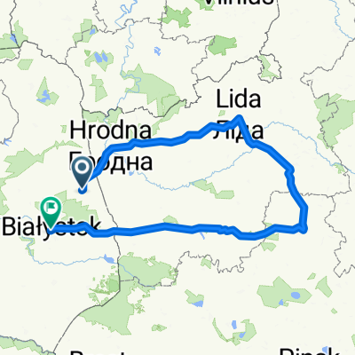
- Podlasie 4 Sokółka-Czarna Białostocka-Sokółka
- Distance
- 55.4 km
- Ascent
- 203 m
- Descent
- 201 m
- Location
- Sokółka, Podlasie Voivodship, Poland
- Szlak Tatarski
- Distance
- 93.8 km
- Ascent
- 339 m
- Descent
- 349 m
- Location
- Sokółka, Podlasie Voivodship, Poland
- Day 1.2
- Distance
- 23.7 km
- Ascent
- 110 m
- Descent
- 125 m
- Location
- Sokółka, Podlasie Voivodship, Poland
- III etap Bohoniki - Bachury
- Distance
- 85.9 km
- Ascent
- 305 m
- Descent
- 332 m
- Location
- Sokółka, Podlasie Voivodship, Poland
- Sokółka, Hałe, Jałówka, Rozedranka Nowa, Janowszczyzna, Jelenia Góra, Sokółka
- Distance
- 28.8 km
- Ascent
- 174 m
- Descent
- 172 m
- Location
- Sokółka, Podlasie Voivodship, Poland
- W POSZUKIWANIU SZLAKU TATARSKIEGO - 5.08.2011
- Distance
- 30.9 km
- Ascent
- 78 m
- Descent
- 81 m
- Location
- Sokółka, Podlasie Voivodship, Poland
- D6 Sokółka Narewka
- Distance
- 104.4 km
- Ascent
- 237 m
- Descent
- 253 m
- Location
- Sokółka, Podlasie Voivodship, Poland
Open it in the app