

De La Lande, Gaël à La Lande, Gaël
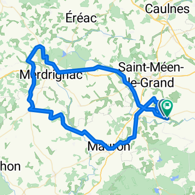
A cycling route starting in Gaël, Brittany Region, France.
Overview
About this route
- 2 h 8 min
- Duration
- 36.2 km
- Distance
- 284 m
- Ascent
- 285 m
- Descent
- 17 km/h
- Avg. speed
- ---
- Max. altitude

Route quality
Waytypes & surfaces along the route
Waytypes
Road
12.7 km
(35 %)
Quiet road
9.4 km
(26 %)
Surfaces
Paved
3.3 km
(9 %)
Unpaved
4.7 km
(13 %)
Gravel
4.3 km
(12 %)
Asphalt
3.3 km
(9 %)
Continue with Bikemap
Use, edit, or download this cycling route
You would like to ride De La Lande, Gaël à La Lande, Gaël or customize it for your own trip? Here is what you can do with this Bikemap route:
Free features
- Save this route as favorite or in collections
- Copy & plan your own version of this route
- Sync your route with Garmin or Wahoo
Premium features
Free trial for 3 days, or one-time payment. More about Bikemap Premium.
- Navigate this route on iOS & Android
- Export a GPX / KML file of this route
- Create your custom printout (try it for free)
- Download this route for offline navigation
Discover more Premium features.
Get Bikemap PremiumFrom our community
Other popular routes starting in Gaël
 10 Le Tertre, Loscouët-sur-Meu to 1 Esplanade de Brocéliande, Paimpont
- Distance
- 19.7 km
- Ascent
- 249 m
- Descent
- 189 m
- Location
- Gaël, Brittany Region, France
 Moderate route in Ploërmel
- Distance
- 35.9 km
- Ascent
- 426 m
- Descent
- 441 m
- Location
- Gaël, Brittany Region, France
 De La Lande, Gaël à La Lande, Gaël
- Distance
- 36.2 km
- Ascent
- 284 m
- Descent
- 285 m
- Location
- Gaël, Brittany Region, France
 St Meen to Ploermel
- Distance
- 45.8 km
- Ascent
- 449 m
- Descent
- 485 m
- Location
- Gaël, Brittany Region, France
 1991 10etapa
- Distance
- 126.7 km
- Ascent
- 654 m
- Descent
- 579 m
- Location
- Gaël, Brittany Region, France
 Route in Muel
- Distance
- 81 km
- Ascent
- 546 m
- Descent
- 551 m
- Location
- Gaël, Brittany Region, France
Open it in the app