Malaha-Santa Fe-04/05/08-GR162
- 55.4 km
- 500 m
- 524 m
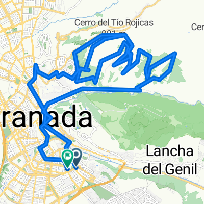
- Huétor Vega, Andalusia, Spain
A cycling route starting in Huétor Vega, Andalusia, Spain.
Overview
Recommended moderate/easy mountain route for beginners, starting with a climb through Cajar up to the quarry area of La Zubia (where several alternative trails are available), where a climb begins on a dirt path through a huge pine forest in the Sierra Natural Park, until reaching the recreational area of Los Llanos in the Monachil neighborhood. Afterwards, a descent on the road down to Monachil.
created this 14 years ago
Route quality
Road
5 km
(42 %)
Track
3.4 km
(29 %)
Paved
3.8 km
(32 %)
Unpaved
2.7 km
(23 %)
Asphalt
3.8 km
(32 %)
Gravel
2.7 km
(23 %)
Undefined
5.3 km
(45 %)
Continue with Bikemap
You would like to ride Huetor-Cantera-Los Llanos-Monachil or customize it for your own trip? Here is what you can do with this Bikemap route:
Free trial for 3 days, or one-time payment. More about Bikemap Premium.
Discover more Premium features.
Get Bikemap PremiumFrom our community
Open it in the app