

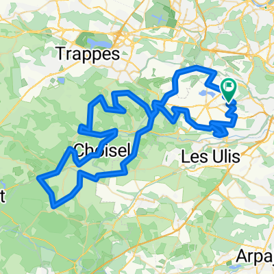
Vauhallan - Chartres
A cycling route starting in Vauhallan, Île-de-France Region, France.
Overview
About this route
- -:--
- Duration
- 75 km
- Distance
- 264 m
- Ascent
- 239 m
- Descent
- ---
- Avg. speed
- ---
- Max. altitude

Continue with Bikemap
Use, edit, or download this cycling route
You would like to ride Vauhallan - Chartres or customize it for your own trip? Here is what you can do with this Bikemap route:
Free features
- Save this route as favorite or in collections
- Copy & plan your own version of this route
- Sync your route with Garmin or Wahoo
Premium features
Free trial for 3 days, or one-time payment. More about Bikemap Premium.
- Navigate this route on iOS & Android
- Export a GPX / KML file of this route
- Create your custom printout (try it for free)
- Download this route for offline navigation
Discover more Premium features.
Get Bikemap PremiumFrom our community
Other popular routes starting in Vauhallan
 From Palaiseau to Boulogne-Billancourt
- Distance
- 68.8 km
- Ascent
- 468 m
- Descent
- 587 m
- Location
- Vauhallan, Île-de-France Region, France
 Vauhallan - Chartres
- Distance
- 75 km
- Ascent
- 264 m
- Descent
- 239 m
- Location
- Vauhallan, Île-de-France Region, France
 PLS du samedi
- Distance
- 105.8 km
- Ascent
- 463 m
- Descent
- 459 m
- Location
- Vauhallan, Île-de-France Region, France
 Itinéraire à partir de 8–12 Rue des Arpentis, Vauhallan
- Distance
- 2.8 km
- Ascent
- 0 m
- Descent
- 37 m
- Location
- Vauhallan, Île-de-France Region, France
 Sortie PCO
- Distance
- 93.8 km
- Ascent
- 629 m
- Descent
- 629 m
- Location
- Vauhallan, Île-de-France Region, France
 3 Rue Étienne Marcel, Igny à 131 Avenue Aristide Briand, Arcueil
- Distance
- 13.7 km
- Ascent
- 75 m
- Descent
- 134 m
- Location
- Vauhallan, Île-de-France Region, France
 Grande Rue du 8 Mai 1945, Vauhallan à Rue Jules Ferry, Igny
- Distance
- 23.8 km
- Ascent
- 238 m
- Descent
- 233 m
- Location
- Vauhallan, Île-de-France Region, France
 De Grande Rue du 8 Mai 1945 55, Vauhallan à Rue de l'Intendant Gobert 1, Villiers-le-Bâcle
- Distance
- 13.3 km
- Ascent
- 64 m
- Descent
- 48 m
- Location
- Vauhallan, Île-de-France Region, France
Open it in the app