
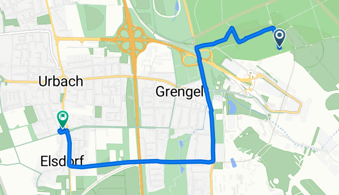
Route nach Friedrich-Hirsch-Straße 467, Köln
A cycling route starting in Eil, North Rhine-Westphalia, Germany.
Overview
About this route
- 42 min
- Duration
- 5.2 km
- Distance
- 0 m
- Ascent
- 30 m
- Descent
- 7.4 km/h
- Avg. speed
- ---
- Max. altitude
Route quality
Waytypes & surfaces along the route
Waytypes
Path
2 km
(39 %)
Quiet road
1.4 km
(28 %)
Surfaces
Paved
3.1 km
(59 %)
Unpaved
1.4 km
(27 %)
Asphalt
2.6 km
(51 %)
Gravel
0.6 km
(11 %)
Continue with Bikemap
Use, edit, or download this cycling route
You would like to ride Route nach Friedrich-Hirsch-Straße 467, Köln or customize it for your own trip? Here is what you can do with this Bikemap route:
Free features
- Save this route as favorite or in collections
- Copy & plan your own version of this route
- Sync your route with Garmin or Wahoo
Premium features
Free trial for 3 days, or one-time payment. More about Bikemap Premium.
- Navigate this route on iOS & Android
- Export a GPX / KML file of this route
- Create your custom printout (try it for free)
- Download this route for offline navigation
Discover more Premium features.
Get Bikemap PremiumFrom our community
Other popular routes starting in Eil
 2021 04 Porz - Königsforst - Hasbach - Lohmar - Inger-Birk - Wahnbachtalsperre und an der Sieg zurück
- Distance
- 73.7 km
- Ascent
- 818 m
- Descent
- 827 m
- Location
- Eil, North Rhine-Westphalia, Germany
 MTB Königsforst vom 22.11.2009
- Distance
- 33.9 km
- Ascent
- 283 m
- Descent
- 285 m
- Location
- Eil, North Rhine-Westphalia, Germany
 2021 03 Porz - Eschmarer Mühle - Hangelar und übers Antonium zurück
- Distance
- 54.8 km
- Ascent
- 309 m
- Descent
- 304 m
- Location
- Eil, North Rhine-Westphalia, Germany
 Im Bergischen Land
- Distance
- 54.8 km
- Ascent
- 550 m
- Descent
- 553 m
- Location
- Eil, North Rhine-Westphalia, Germany
 Eil - Troisdorf - Altenrath - (Flughafen) - Eil
- Distance
- 32.5 km
- Ascent
- 127 m
- Descent
- 118 m
- Location
- Eil, North Rhine-Westphalia, Germany
 Bergische Trainingsrunde
- Distance
- 82.1 km
- Ascent
- 897 m
- Descent
- 878 m
- Location
- Eil, North Rhine-Westphalia, Germany
 MTB 5.12.2009
- Distance
- 35.9 km
- Ascent
- 373 m
- Descent
- 369 m
- Location
- Eil, North Rhine-Westphalia, Germany
 MTB Königsforst vom 22.11.2009
- Distance
- 33.9 km
- Ascent
- 284 m
- Descent
- 284 m
- Location
- Eil, North Rhine-Westphalia, Germany
Open it in the app