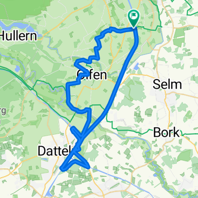
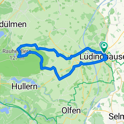
Seppenrade Halterner Stausee
A cycling route starting in Lüdinghausen, North Rhine-Westphalia, Germany.
Overview
About this route
Die Tour beginnt auf dem Parkplatz am Rosengarten in Seppenrade und endet auch dort. Sie führt zum Flugplatz Borkenberge über den Truppenübungsplatz nach Sythen und von dort weiter zum Halterner Stausee, entlang dem Hullerner See zurück zum Rosendorf Seppenrade. Die Tour ist für Freizeitradfahrer gedacht.
- -:--
- Duration
- 32.6 km
- Distance
- 104 m
- Ascent
- 110 m
- Descent
- ---
- Avg. speed
- 103 m
- Avg. speed
Route quality
Waytypes & surfaces along the route
Waytypes
Quiet road
18.7 km
(57 %)
Path
5.6 km
(17 %)
Surfaces
Paved
21.4 km
(66 %)
Unpaved
7 km
(21 %)
Asphalt
18.8 km
(58 %)
Gravel
5.4 km
(16 %)
Route highlights
Points of interest along the route
Point of interest after 9.3 km
Flugplatz Borkenberge
Point of interest after 9.5 km
Gasthaus
Point of interest after 10.1 km
Truppenübungsplatz
Point of interest after 14.2 km
Gasthaus, Hotel
Point of interest after 18.8 km
Gasthaus
Point of interest after 20.4 km
Gasthaus
Continue with Bikemap
Use, edit, or download this cycling route
You would like to ride Seppenrade Halterner Stausee or customize it for your own trip? Here is what you can do with this Bikemap route:
Free features
- Save this route as favorite or in collections
- Copy & plan your own version of this route
- Sync your route with Garmin or Wahoo
Premium features
Free trial for 3 days, or one-time payment. More about Bikemap Premium.
- Navigate this route on iOS & Android
- Export a GPX / KML file of this route
- Create your custom printout (try it for free)
- Download this route for offline navigation
Discover more Premium features.
Get Bikemap PremiumFrom our community
Other popular routes starting in Lüdinghausen
- 3 Schlössertour
- Distance
- 48.6 km
- Ascent
- 1,569 m
- Descent
- 1,577 m
- Location
- Lüdinghausen, North Rhine-Westphalia, Germany
- AR23_37-Lüdingh-Bechtrup-Gettrup-Senden-Elvert-Beerenbrock
- Distance
- 37.4 km
- Ascent
- 52 m
- Descent
- 51 m
- Location
- Lüdinghausen, North Rhine-Westphalia, Germany
- Lüdi 01 - 3-Schlösser-Runde
- Distance
- 50.8 km
- Ascent
- 1,047 m
- Descent
- 1,047 m
- Location
- Lüdinghausen, North Rhine-Westphalia, Germany
- B474 13, Lüdinghausen nach Dattelner Straße 9, Lüdinghausen
- Distance
- 26.5 km
- Ascent
- 218 m
- Descent
- 216 m
- Location
- Lüdinghausen, North Rhine-Westphalia, Germany
- Lüdinghausen-Haltern-Olfen
- Distance
- 52.3 km
- Ascent
- 172 m
- Descent
- 173 m
- Location
- Lüdinghausen, North Rhine-Westphalia, Germany
- Lüdingh., Sendenhorst, Ottmarsb. 105km
- Distance
- 104.4 km
- Ascent
- 268 m
- Descent
- 269 m
- Location
- Lüdinghausen, North Rhine-Westphalia, Germany
- Nördlich von Lüdinghausen, 32,5 km
- Distance
- 32.5 km
- Ascent
- 45 m
- Descent
- 45 m
- Location
- Lüdinghausen, North Rhine-Westphalia, Germany
- Lüdinghausen - Schloss Nordkirchen (Track)
- Distance
- 22.8 km
- Ascent
- 52 m
- Descent
- 53 m
- Location
- Lüdinghausen, North Rhine-Westphalia, Germany
Open it in the app