

Neuried zum Karwendelhaus und zurück
A cycling route starting in Scharnitz, Tyrol, Austria.
Overview
About this route
This tour is a 2-3 day trip with an overnight stay at Karwendelhaus, suitable for bikers who feel at home on mountain bikes and have the appropriate fitness. The ascent at Kesselberg is very demanding, and to conclude, the long climb up to Karwendelhaus. Not suitable for children up to the age of 16 due to the tour's difficulty, length, steepness, and the challenging sections during the descent. Still, it is a very rewarding and beautiful tour.
- -:--
- Duration
- 248.6 km
- Distance
- 3,146 m
- Ascent
- 3,146 m
- Descent
- ---
- Avg. speed
- ---
- Max. altitude

Continue with Bikemap
Use, edit, or download this cycling route
You would like to ride Neuried zum Karwendelhaus und zurück or customize it for your own trip? Here is what you can do with this Bikemap route:
Free features
- Save this route as favorite or in collections
- Copy & plan your own version of this route
- Split it into stages to create a multi-day tour
- Sync your route with Garmin or Wahoo
Premium features
Free trial for 3 days, or one-time payment. More about Bikemap Premium.
- Navigate this route on iOS & Android
- Export a GPX / KML file of this route
- Create your custom printout (try it for free)
- Download this route for offline navigation
Discover more Premium features.
Get Bikemap PremiumFrom our community
Other popular routes starting in Scharnitz
 Gießenbach - Isarursprung
- Distance
- 15.3 km
- Ascent
- 272 m
- Descent
- 113 m
- Location
- Scharnitz, Tyrol, Austria
 Stetige Fahrt zum Isarursprung
- Distance
- 12.2 km
- Ascent
- 306 m
- Descent
- 116 m
- Location
- Scharnitz, Tyrol, Austria
 Route in Scharnitz
- Distance
- 13.1 km
- Ascent
- 437 m
- Descent
- 196 m
- Location
- Scharnitz, Tyrol, Austria
 Hinterriss - Falkenhütte
- Distance
- 31.7 km
- Ascent
- 971 m
- Descent
- 975 m
- Location
- Scharnitz, Tyrol, Austria
 Möslalm
- Distance
- 24.7 km
- Ascent
- 447 m
- Descent
- 447 m
- Location
- Scharnitz, Tyrol, Austria
 Neuried zum Karwendelhaus und zurück
- Distance
- 248.6 km
- Ascent
- 3,146 m
- Descent
- 3,146 m
- Location
- Scharnitz, Tyrol, Austria
 Isar-Radweg
- Distance
- 275.9 km
- Ascent
- 138 m
- Descent
- 793 m
- Location
- Scharnitz, Tyrol, Austria
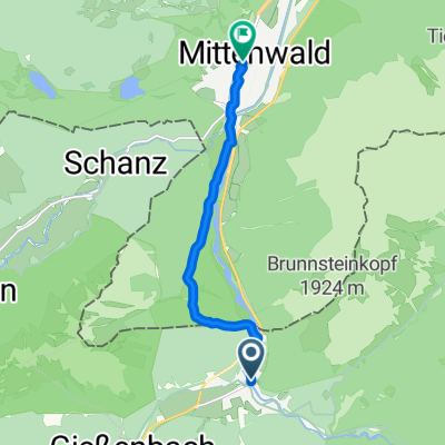 Von Scharnitz bis Mittenwald
- Distance
- 7.7 km
- Ascent
- 79 m
- Descent
- 130 m
- Location
- Scharnitz, Tyrol, Austria
Open it in the app