
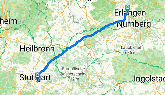
Stuttgart-Erlangen 2011
A cycling route starting in Ostfildern, Baden-Württemberg, Germany.
Overview
About this route
- -:--
- Duration
- 193.5 km
- Distance
- 1,060 m
- Ascent
- 1,189 m
- Descent
- ---
- Avg. speed
- ---
- Avg. speed
Route quality
Waytypes & surfaces along the route
Waytypes
Road
59.6 km
(31 %)
Quiet road
48.6 km
(25 %)
Surfaces
Paved
132.5 km
(68 %)
Unpaved
9.4 km
(5 %)
Asphalt
126.1 km
(65 %)
Paved (undefined)
5.2 km
(3 %)
Continue with Bikemap
Use, edit, or download this cycling route
You would like to ride Stuttgart-Erlangen 2011 or customize it for your own trip? Here is what you can do with this Bikemap route:
Free features
- Save this route as favorite or in collections
- Copy & plan your own version of this route
- Split it into stages to create a multi-day tour
- Sync your route with Garmin or Wahoo
Premium features
Free trial for 3 days, or one-time payment. More about Bikemap Premium.
- Navigate this route on iOS & Android
- Export a GPX / KML file of this route
- Create your custom printout (try it for free)
- Download this route for offline navigation
Discover more Premium features.
Get Bikemap PremiumFrom our community
Other popular routes starting in Ostfildern
 Feierabendroute Ostfildern - Degerloch - Sillenbuch - Ostfildern
- Distance
- 19.3 km
- Ascent
- 263 m
- Descent
- 177 m
- Location
- Ostfildern, Baden-Württemberg, Germany
 Abendrunde eine Stunde
- Distance
- 17.5 km
- Ascent
- 95 m
- Descent
- 93 m
- Location
- Ostfildern, Baden-Württemberg, Germany
 Hef- Weil- Steinprügel
- Distance
- 7.9 km
- Ascent
- 234 m
- Descent
- 233 m
- Location
- Ostfildern, Baden-Württemberg, Germany
 Sonntagsrunde Vaihingen Solitude Leinfelden tracked
- Distance
- 57 km
- Ascent
- 579 m
- Descent
- 579 m
- Location
- Ostfildern, Baden-Württemberg, Germany
 Schnarnhausen-Rundweg
- Distance
- 17.4 km
- Ascent
- 198 m
- Descent
- 168 m
- Location
- Ostfildern, Baden-Württemberg, Germany
 Scharnhauser Park-Ruit-Obertürkheim-Weil-Zollberg-Scharnhauser Park
- Distance
- 23.2 km
- Ascent
- 232 m
- Descent
- 285 m
- Location
- Ostfildern, Baden-Württemberg, Germany
 Riedenberg-Urach-Lenningen-Kirchheim-retour
- Distance
- 110.5 km
- Ascent
- 1,055 m
- Descent
- 1,055 m
- Location
- Ostfildern, Baden-Württemberg, Germany
 Haschberg
- Distance
- 2.3 km
- Ascent
- 54 m
- Descent
- 52 m
- Location
- Ostfildern, Baden-Württemberg, Germany
Open it in the app