

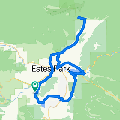
1050 CR-67, Estes Park to 1050 CR-67, Estes Park
A cycling route starting in Estes Park, Colorado, United States.
Overview
About this route
- 1 h 37 min
- Duration
- 24.8 km
- Distance
- 248 m
- Ascent
- 249 m
- Descent
- 15.4 km/h
- Avg. speed
- ---
- Max. altitude

Route quality
Waytypes & surfaces along the route
Waytypes
Cycleway
11.7 km
(47 %)
Pedestrian area
4.7 km
(19 %)
Surfaces
Paved
20.5 km
(83 %)
Unpaved
0.6 km
(2 %)
Paved (undefined)
11.3 km
(45 %)
Asphalt
7.7 km
(31 %)
Continue with Bikemap
Use, edit, or download this cycling route
You would like to ride 1050 CR-67, Estes Park to 1050 CR-67, Estes Park or customize it for your own trip? Here is what you can do with this Bikemap route:
Free features
- Save this route as favorite or in collections
- Copy & plan your own version of this route
- Sync your route with Garmin or Wahoo
Premium features
Free trial for 3 days, or one-time payment. More about Bikemap Premium.
- Navigate this route on iOS & Android
- Export a GPX / KML file of this route
- Create your custom printout (try it for free)
- Download this route for offline navigation
Discover more Premium features.
Get Bikemap PremiumFrom our community
Other popular routes starting in Estes Park
 Sky Pond
- Distance
- 12.5 km
- Ascent
- 568 m
- Descent
- 573 m
- Location
- Estes Park, Colorado, United States
 1055 Griffith Ct, Estes Park to 1050 Griffith Ct, Estes Park
- Distance
- 32.6 km
- Ascent
- 579 m
- Descent
- 578 m
- Location
- Estes Park, Colorado, United States
 Camp St. Malo to Nederland
- Distance
- 49.1 km
- Ascent
- 771 m
- Descent
- 897 m
- Location
- Estes Park, Colorado, United States
 Lake Estes
- Distance
- 6.5 km
- Ascent
- 83 m
- Descent
- 83 m
- Location
- Estes Park, Colorado, United States
 Wind River Pass
- Distance
- 85.7 km
- Ascent
- 1,417 m
- Descent
- 1,417 m
- Location
- Estes Park, Colorado, United States
 1050 CR-67, Estes Park to 1050 CR-67, Estes Park
- Distance
- 24.8 km
- Ascent
- 248 m
- Descent
- 249 m
- Location
- Estes Park, Colorado, United States
 Lake Rounds
- Distance
- 8.8 km
- Ascent
- 372 m
- Descent
- 372 m
- Location
- Estes Park, Colorado, United States
 Mary's Lake Road 2
- Distance
- 9.9 km
- Ascent
- 178 m
- Descent
- 180 m
- Location
- Estes Park, Colorado, United States
Open it in the app