

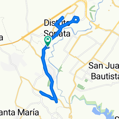
Cerro Ocotes
A cycling route starting in Santa Clara Ocoyucan, Puebla, Mexico.
Overview
About this route
Urban, suburban, and gravel areas
- -:--
- Duration
- 6.5 km
- Distance
- 266 m
- Ascent
- 12 m
- Descent
- ---
- Avg. speed
- 2,328 m
- Max. altitude

Route quality
Waytypes & surfaces along the route
Waytypes
Quiet road
2.6 km
(40 %)
Road
1.5 km
(23 %)
Surfaces
Paved
2.1 km
(32 %)
Asphalt
1.6 km
(25 %)
Concrete
0.5 km
(7 %)
Undefined
4.5 km
(68 %)
Continue with Bikemap
Use, edit, or download this cycling route
You would like to ride Cerro Ocotes or customize it for your own trip? Here is what you can do with this Bikemap route:
Free features
- Save this route as favorite or in collections
- Copy & plan your own version of this route
- Sync your route with Garmin or Wahoo
Premium features
Free trial for 3 days, or one-time payment. More about Bikemap Premium.
- Navigate this route on iOS & Android
- Export a GPX / KML file of this route
- Create your custom printout (try it for free)
- Download this route for offline navigation
Discover more Premium features.
Get Bikemap PremiumFrom our community
Other popular routes starting in Santa Clara Ocoyucan
 Santa Isabel- Serdan - Loreto - Castillotla
- Distance
- 49 km
- Ascent
- 548 m
- Descent
- 538 m
- Location
- Santa Clara Ocoyucan, Puebla, Mexico
 Cerro Ocotes
- Distance
- 6.5 km
- Ascent
- 266 m
- Descent
- 12 m
- Location
- Santa Clara Ocoyucan, Puebla, Mexico
 Lomas III
- Distance
- 7.9 km
- Ascent
- 97 m
- Descent
- 99 m
- Location
- Santa Clara Ocoyucan, Puebla, Mexico
 Calle Belfast, San Bernardino Tlaxcalancingo to Calle Belfast, San Bernardino Tlaxcalancingo
- Distance
- 35.5 km
- Ascent
- 373 m
- Descent
- 372 m
- Location
- Santa Clara Ocoyucan, Puebla, Mexico
 De Calle Tehuacán 8, San Andrés Cholula a Calle Tehuacán 8, San Andrés Cholula
- Distance
- 7.2 km
- Ascent
- 75 m
- Descent
- 68 m
- Location
- Santa Clara Ocoyucan, Puebla, Mexico
 Ruta Lomas I
- Distance
- 8.7 km
- Ascent
- 100 m
- Descent
- 96 m
- Location
- Santa Clara Ocoyucan, Puebla, Mexico
 De Boulevard de Los Volcanes, Ocoyucan a Boulevard de Los Volcanes, Ocoyucan
- Distance
- 36.8 km
- Ascent
- 201 m
- Descent
- 200 m
- Location
- Santa Clara Ocoyucan, Puebla, Mexico
 Privada Belfast, San Bernardino Tlaxcalancingo to Privada Belfast, San Bernardino Tlaxcalancingo
- Distance
- 21.1 km
- Ascent
- 204 m
- Descent
- 204 m
- Location
- Santa Clara Ocoyucan, Puebla, Mexico
Open it in the app