

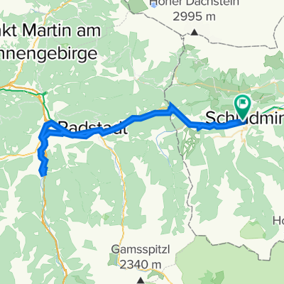
Rohrmoos Tour
A cycling route starting in Schladming, Styria, Austria.
Overview
About this route
- -:--
- Duration
- 26.4 km
- Distance
- 505 m
- Ascent
- 504 m
- Descent
- ---
- Avg. speed
- 1,107 m
- Max. altitude

Route highlights
Points of interest along the route
Point of interest after 7.9 km
Koupacka
Continue with Bikemap
Use, edit, or download this cycling route
You would like to ride Rohrmoos Tour or customize it for your own trip? Here is what you can do with this Bikemap route:
Free features
- Save this route as favorite or in collections
- Copy & plan your own version of this route
- Sync your route with Garmin or Wahoo
Premium features
Free trial for 3 days, or one-time payment. More about Bikemap Premium.
- Navigate this route on iOS & Android
- Export a GPX / KML file of this route
- Create your custom printout (try it for free)
- Download this route for offline navigation
Discover more Premium features.
Get Bikemap PremiumFrom our community
Other popular routes starting in Schladming
 Sonnseitn Tour
- Distance
- 26.4 km
- Ascent
- 518 m
- Descent
- 518 m
- Location
- Schladming, Styria, Austria
 Ennstalrunde
- Distance
- 67.7 km
- Ascent
- 608 m
- Descent
- 609 m
- Location
- Schladming, Styria, Austria
 Planai
- Distance
- 17.9 km
- Ascent
- 1,105 m
- Descent
- 96 m
- Location
- Schladming, Styria, Austria
 Schladming Flachau Rundweg
- Distance
- 61.3 km
- Ascent
- 224 m
- Descent
- 223 m
- Location
- Schladming, Styria, Austria
 Ramsau Tuerlwand
- Distance
- 32.8 km
- Ascent
- 1,350 m
- Descent
- 1,350 m
- Location
- Schladming, Styria, Austria
 Top 6 Schladming 08 medium
- Distance
- 47.4 km
- Ascent
- 1,654 m
- Descent
- 1,661 m
- Location
- Schladming, Styria, Austria
 Schladming Bergstation Planei ins Tal
- Distance
- 36.8 km
- Ascent
- 419 m
- Descent
- 1,501 m
- Location
- Schladming, Styria, Austria
 sch-ram-filz-alt-rad-sch
- Distance
- 61.5 km
- Ascent
- 754 m
- Descent
- 753 m
- Location
- Schladming, Styria, Austria
Open it in the app