

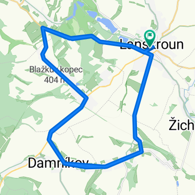
Lanškroun-pila Třebovice-Anenská Studánka-Madějov
A cycling route starting in Lanškroun, Pardubický kraj, Czechia.
Overview
About this route
The route follows the old Damníkov road, then back via Anenská spring and Trpik, Mladějov, Rychnov, further along the polder embankment to the edge of Žichlínka and from the firefighters by the back road to the edge of Lanškroun and through the house gardens.
- -:--
- Duration
- 39.3 km
- Distance
- 263 m
- Ascent
- 265 m
- Descent
- ---
- Avg. speed
- ---
- Max. altitude

Route quality
Waytypes & surfaces along the route
Waytypes
Road
25.6 km
(65 %)
Quiet road
5.9 km
(15 %)
Surfaces
Paved
17.7 km
(45 %)
Unpaved
4.7 km
(12 %)
Asphalt
17.7 km
(45 %)
Gravel
2.4 km
(6 %)
Continue with Bikemap
Use, edit, or download this cycling route
You would like to ride Lanškroun-pila Třebovice-Anenská Studánka-Madějov or customize it for your own trip? Here is what you can do with this Bikemap route:
Free features
- Save this route as favorite or in collections
- Copy & plan your own version of this route
- Sync your route with Garmin or Wahoo
Premium features
Free trial for 3 days, or one-time payment. More about Bikemap Premium.
- Navigate this route on iOS & Android
- Export a GPX / KML file of this route
- Create your custom printout (try it for free)
- Download this route for offline navigation
Discover more Premium features.
Get Bikemap PremiumFrom our community
Other popular routes starting in Lanškroun
 Sázava - Albrechtice - Lanškroun
- Distance
- 6.3 km
- Ascent
- 27 m
- Descent
- 28 m
- Location
- Lanškroun, Pardubický kraj, Czechia
 Regionem Orlicka 2017 - I. etapa
- Distance
- 76.7 km
- Ascent
- 439 m
- Descent
- 440 m
- Location
- Lanškroun, Pardubický kraj, Czechia
 ll.18.7.Ut.Lanškroun-M.Trebova-Mes.Trnavka-Plumlov
- Distance
- 79.7 km
- Ascent
- 520 m
- Descent
- 609 m
- Location
- Lanškroun, Pardubický kraj, Czechia
 1.et.MZM2018-Verměřovice
- Distance
- 46.3 km
- Ascent
- 491 m
- Descent
- 491 m
- Location
- Lanškroun, Pardubický kraj, Czechia
 Lanškroun - Třebovské stěny - Lanškrounské rybníky
- Distance
- 25.7 km
- Ascent
- 381 m
- Descent
- 381 m
- Location
- Lanškroun, Pardubický kraj, Czechia
 Z Lanškrouna na Kozlovský kopec
- Distance
- 49.4 km
- Ascent
- 538 m
- Descent
- 538 m
- Location
- Lanškroun, Pardubický kraj, Czechia
 Lanškrounská kopa 60km cyklo
- Distance
- 57.8 km
- Ascent
- 1,022 m
- Descent
- 1,028 m
- Location
- Lanškroun, Pardubický kraj, Czechia
 Lanškroun-pila Třebovice-Anenská Studánka-Madějov
- Distance
- 39.3 km
- Ascent
- 263 m
- Descent
- 265 m
- Location
- Lanškroun, Pardubický kraj, Czechia
Open it in the app