

Temerin - Senta
A cycling route starting in Temerin, Vojvodina, Serbia.
Overview
About this route
- 3 h 2 min
- Duration
- 70.6 km
- Distance
- 432 m
- Ascent
- 421 m
- Descent
- 23.3 km/h
- Avg. speed
- ---
- Max. altitude

Route quality
Waytypes & surfaces along the route
Waytypes
Quiet road
8.5 km
(12 %)
Track
4.2 km
(6 %)
Surfaces
Paved
38.1 km
(54 %)
Unpaved
0.7 km
(1 %)
Asphalt
37.4 km
(53 %)
Paved (undefined)
0.7 km
(1 %)
Continue with Bikemap
Use, edit, or download this cycling route
You would like to ride Temerin - Senta or customize it for your own trip? Here is what you can do with this Bikemap route:
Free features
- Save this route as favorite or in collections
- Copy & plan your own version of this route
- Sync your route with Garmin or Wahoo
Premium features
Free trial for 3 days, or one-time payment. More about Bikemap Premium.
- Navigate this route on iOS & Android
- Export a GPX / KML file of this route
- Create your custom printout (try it for free)
- Download this route for offline navigation
Discover more Premium features.
Get Bikemap PremiumFrom our community
Other popular routes starting in Temerin
 TdB, dzień 3
- Distance
- 108.5 km
- Ascent
- 88 m
- Descent
- 44 m
- Location
- Temerin, Vojvodina, Serbia
 Temerin-Óbecse-Muzslya-Temerin
- Distance
- 132 km
- Ascent
- 46 m
- Descent
- 46 m
- Location
- Temerin, Vojvodina, Serbia
 Temerin-Óbecse
- Distance
- 31.2 km
- Ascent
- 8 m
- Descent
- 11 m
- Location
- Temerin, Vojvodina, Serbia
 Húsvéti ,,körmenet"
- Distance
- 26.8 km
- Ascent
- 301 m
- Descent
- 303 m
- Location
- Temerin, Vojvodina, Serbia
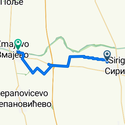 zmajevo
- Distance
- 12.4 km
- Ascent
- 3 m
- Descent
- 0 m
- Location
- Temerin, Vojvodina, Serbia
 Temerin - Senta
- Distance
- 70.6 km
- Ascent
- 432 m
- Descent
- 421 m
- Location
- Temerin, Vojvodina, Serbia
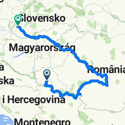 2013 cyklo rumunsko
- Distance
- 1,726.6 km
- Ascent
- 4,412 m
- Descent
- 4,352 m
- Location
- Temerin, Vojvodina, Serbia
 Batyu tábor
- Distance
- 57.6 km
- Ascent
- 43 m
- Descent
- 19 m
- Location
- Temerin, Vojvodina, Serbia
Open it in the app