
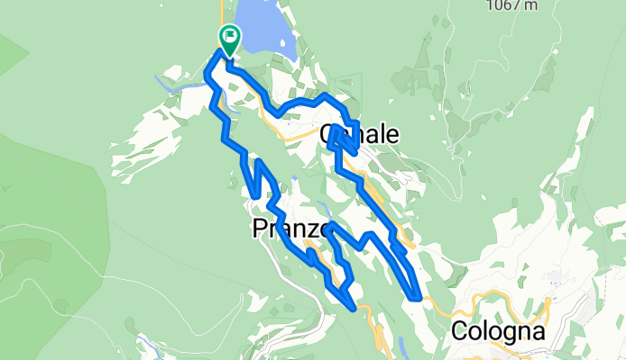
736. Tenno Tour (Cross Country)
A cycling route starting in Tenno, Trentino-Alto Adige, Italy.
Overview
About this route
Un tour tecnicamente molto facile, in gran parte su asfalto, percorribile tranquillamente anche con una bici gravel.
- 48 min
- Duration
- 10.3 km
- Distance
- 371 m
- Ascent
- 369 m
- Descent
- 13 km/h
- Avg. speed
- ---
- Avg. speed

Route quality
Waytypes & surfaces along the route
Waytypes
Quiet road
3.7 km
(36 %)
Busy road
2.9 km
(29 %)
Surfaces
Paved
6.5 km
(63 %)
Unpaved
1.3 km
(13 %)
Asphalt
5.9 km
(57 %)
Ground
1.2 km
(12 %)
Continue with Bikemap
Use, edit, or download this cycling route
You would like to ride 736. Tenno Tour (Cross Country) or customize it for your own trip? Here is what you can do with this Bikemap route:
Free features
- Save this route as favorite or in collections
- Copy & plan your own version of this route
- Sync your route with Garmin or Wahoo
Premium features
Free trial for 3 days, or one-time payment. More about Bikemap Premium.
- Navigate this route on iOS & Android
- Export a GPX / KML file of this route
- Create your custom printout (try it for free)
- Download this route for offline navigation
Discover more Premium features.
Get Bikemap PremiumFrom our community
Other popular routes starting in Tenno
 Lago Aussicht
- Distance
- 53.6 km
- Ascent
- 2,543 m
- Descent
- 2,798 m
- Location
- Tenno, Trentino-Alto Adige, Italy
 Tenno - Sella di Calino - Tenno
- Distance
- 24.7 km
- Ascent
- 669 m
- Descent
- 661 m
- Location
- Tenno, Trentino-Alto Adige, Italy
 Rund um den Tennosee
- Distance
- 9.7 km
- Ascent
- 337 m
- Descent
- 312 m
- Location
- Tenno, Trentino-Alto Adige, Italy
 Recording from 7 Dicembre 11:28
- Distance
- 3.8 km
- Ascent
- 146 m
- Descent
- 109 m
- Location
- Tenno, Trentino-Alto Adige, Italy
 Arco - Madonna di Campiglio - Dimaro (Marilleva)
- Distance
- 80.9 km
- Ascent
- 2,122 m
- Descent
- 1,487 m
- Location
- Tenno, Trentino-Alto Adige, Italy
 Strada Statale nach Strada Statale
- Distance
- 12.7 km
- Ascent
- 567 m
- Descent
- 567 m
- Location
- Tenno, Trentino-Alto Adige, Italy
 Vrchařská prémie na Mt. Misone
- Distance
- 21.8 km
- Ascent
- 1,257 m
- Descent
- 1,245 m
- Location
- Tenno, Trentino-Alto Adige, Italy
 Od Lago di Tenno přes Riva del Garda do Nago-Torbole
- Distance
- 17.9 km
- Ascent
- 262 m
- Descent
- 628 m
- Location
- Tenno, Trentino-Alto Adige, Italy
Open it in the app