

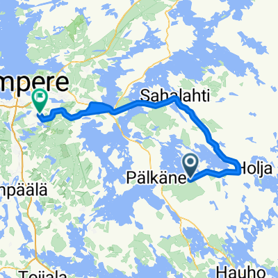
Monaalantie 1–21, Haukila to Koskelantie 23, Helsinki
A cycling route starting in Pälkäne, Pirkanmaa, Finland.
Overview
About this route
- 8 h 48 min
- Duration
- 153.8 km
- Distance
- 244 m
- Ascent
- 307 m
- Descent
- 17.5 km/h
- Avg. speed
- 117 m
- Max. altitude
Route quality
Waytypes & surfaces along the route
Waytypes
Cycleway
87.7 km
(57 %)
Road
36.9 km
(24 %)
Surfaces
Paved
132.3 km
(86 %)
Unpaved
16.9 km
(11 %)
Asphalt
120 km
(78 %)
Paved (undefined)
12.3 km
(8 %)
Continue with Bikemap
Use, edit, or download this cycling route
You would like to ride Monaalantie 1–21, Haukila to Koskelantie 23, Helsinki or customize it for your own trip? Here is what you can do with this Bikemap route:
Free features
- Save this route as favorite or in collections
- Copy & plan your own version of this route
- Split it into stages to create a multi-day tour
- Sync your route with Garmin or Wahoo
Premium features
Free trial for 3 days, or one-time payment. More about Bikemap Premium.
- Navigate this route on iOS & Android
- Export a GPX / KML file of this route
- Create your custom printout (try it for free)
- Download this route for offline navigation
Discover more Premium features.
Get Bikemap PremiumFrom our community
Other popular routes starting in Pälkäne
 Monaalantie 1–21, Haukila to Koskelantie 23, Helsinki
- Distance
- 153.8 km
- Ascent
- 244 m
- Descent
- 307 m
- Location
- Pälkäne, Pirkanmaa, Finland
 Recorded via Apple Watch - 7.9.2021, 16.40
- Distance
- 15.9 km
- Ascent
- 341 m
- Descent
- 336 m
- Location
- Pälkäne, Pirkanmaa, Finland
 Pälkänevedentie to Tamppikuja 1a
- Distance
- 152.1 km
- Ascent
- 367 m
- Descent
- 340 m
- Location
- Pälkäne, Pirkanmaa, Finland
 400km brevet
- Distance
- 399.7 km
- Ascent
- 389 m
- Descent
- 390 m
- Location
- Pälkäne, Pirkanmaa, Finland
 Syrjänharjuntie 3, Pälkäne to Syrjänharjuntie 4, Pälkäne
- Distance
- 17.1 km
- Ascent
- 121 m
- Descent
- 125 m
- Location
- Pälkäne, Pirkanmaa, Finland
 Pälkäne-Tre
- Distance
- 108.9 km
- Ascent
- 281 m
- Descent
- 260 m
- Location
- Pälkäne, Pirkanmaa, Finland
 21. nap Tommola-Keuruu
- Distance
- 147.1 km
- Ascent
- 444 m
- Descent
- 430 m
- Location
- Pälkäne, Pirkanmaa, Finland
 Pälkäneveden kierros
- Distance
- 49.8 km
- Ascent
- 332 m
- Descent
- 320 m
- Location
- Pälkäne, Pirkanmaa, Finland
Open it in the app