

Pommes in Hoopte
A cycling route starting in Seevetal, Lower Saxony, Germany.
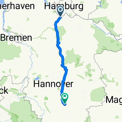
Overview
About this route
Hunger? Quickly to Hoopte to grab a bite at the ferry dock. Pay attention to the ferry times, in winter the ferry does not operate and the snack bar will be closed.
- -:--
- Duration
- 40.6 km
- Distance
- 93 m
- Ascent
- 91 m
- Descent
- ---
- Avg. speed
- 61 m
- Max. altitude

Route quality
Waytypes & surfaces along the route
Waytypes
Quiet road
19.5 km
(48 %)
Road
9.3 km
(23 %)
Surfaces
Paved
32.1 km
(79 %)
Asphalt
26.8 km
(66 %)
Concrete
3.7 km
(9 %)
Continue with Bikemap
Use, edit, or download this cycling route
You would like to ride Pommes in Hoopte or customize it for your own trip? Here is what you can do with this Bikemap route:
Free features
- Save this route as favorite or in collections
- Copy & plan your own version of this route
- Sync your route with Garmin or Wahoo
Premium features
Free trial for 3 days, or one-time payment. More about Bikemap Premium.
- Navigate this route on iOS & Android
- Export a GPX / KML file of this route
- Create your custom printout (try it for free)
- Download this route for offline navigation
Discover more Premium features.
Get Bikemap PremiumFrom our community
Other popular routes starting in Seevetal
 Alpe d'Hittfeld (120km)
- Distance
- 124.6 km
- Ascent
- 535 m
- Descent
- 535 m
- Location
- Seevetal, Lower Saxony, Germany
 Seevestraße 21B, Seevetal nach Seevestraße 21B, Seevetal
- Distance
- 52.8 km
- Ascent
- 285 m
- Descent
- 293 m
- Location
- Seevetal, Lower Saxony, Germany
 Fleestedt->Moisburg->Schierhorn->Fleestedt
- Distance
- 78.4 km
- Ascent
- 525 m
- Descent
- 524 m
- Location
- Seevetal, Lower Saxony, Germany
 Seevetal - Bad Salzdetfurth
- Distance
- 178.4 km
- Ascent
- 610 m
- Descent
- 605 m
- Location
- Seevetal, Lower Saxony, Germany
 Sottorf to Hamburg
- Distance
- 26.2 km
- Ascent
- 204 m
- Descent
- 292 m
- Location
- Seevetal, Lower Saxony, Germany
 Wilhelm-Cohrs-Weg 20A, Seevetal nach Wilhelm-Cohrs-Weg 22, Seevetal
- Distance
- 41.5 km
- Ascent
- 53 m
- Descent
- 53 m
- Location
- Seevetal, Lower Saxony, Germany
 Hittfeld Südrunde Variante 1
- Distance
- 15.4 km
- Ascent
- 62 m
- Descent
- 57 m
- Location
- Seevetal, Lower Saxony, Germany
 Mühlenweg, Seevetal nach Peperdiekshöhe, Seevetal
- Distance
- 4 km
- Ascent
- 43 m
- Descent
- 41 m
- Location
- Seevetal, Lower Saxony, Germany
Open it in the app