

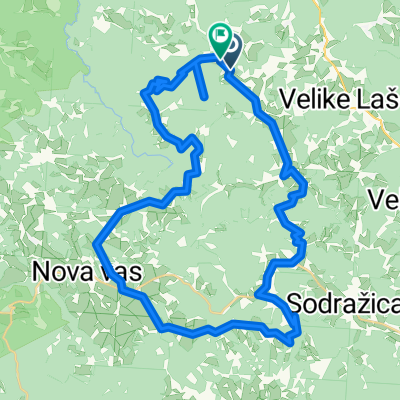
From Trubar to Cankar and back CLASSIC
A cycling route starting in Velike Lašče, Občina Velike Lašče, Slovenia.
Overview
About this route
- -:--
- Duration
- 112.3 km
- Distance
- 734 m
- Ascent
- 734 m
- Descent
- ---
- Avg. speed
- ---
- Max. altitude

Route quality
Waytypes & surfaces along the route
Waytypes
Road
43.8 km
(39 %)
Quiet road
25.8 km
(23 %)
Surfaces
Paved
79.7 km
(71 %)
Unpaved
2.2 km
(2 %)
Asphalt
76.4 km
(68 %)
Paved (undefined)
3.4 km
(3 %)
Continue with Bikemap
Use, edit, or download this cycling route
You would like to ride From Trubar to Cankar and back CLASSIC or customize it for your own trip? Here is what you can do with this Bikemap route:
Free features
- Save this route as favorite or in collections
- Copy & plan your own version of this route
- Split it into stages to create a multi-day tour
- Sync your route with Garmin or Wahoo
Premium features
Free trial for 3 days, or one-time payment. More about Bikemap Premium.
- Navigate this route on iOS & Android
- Export a GPX / KML file of this route
- Create your custom printout (try it for free)
- Download this route for offline navigation
Discover more Premium features.
Get Bikemap PremiumFrom our community
Other popular routes starting in Velike Lašče
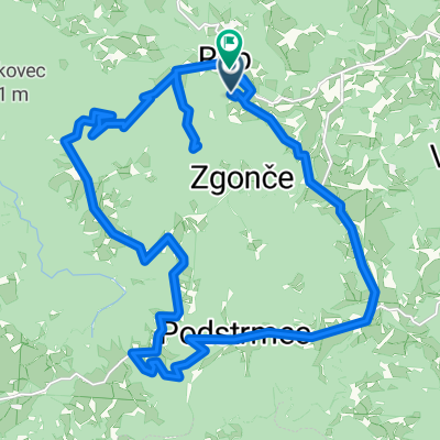
 Rob - Rob 50 km
- Distance
- 49.3 km
- Ascent
- 1,644 m
- Descent
- 1,648 m
- Location
- Velike Lašče, Občina Velike Lašče, Slovenia
 V.Lašče-Nova vas-Sv.Gregor
- Distance
- 44.2 km
- Ascent
- 650 m
- Descent
- 657 m
- Location
- Velike Lašče, Občina Velike Lašče, Slovenia
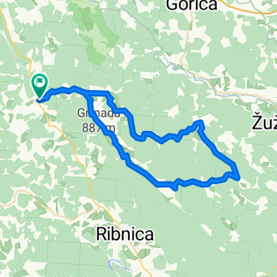
 kLANCI
- Distance
- 63.3 km
- Ascent
- 710 m
- Descent
- 713 m
- Location
- Velike Lašče, Občina Velike Lašče, Slovenia
 Rob - Rob 29km circle
- Distance
- 29 km
- Ascent
- 1,083 m
- Descent
- 1,153 m
- Location
- Velike Lašče, Občina Velike Lašče, Slovenia
 AŠČE,ZDENv.LSKA VAS,LJ,POD TURJAK,V.LAŠČE
- Distance
- 61 km
- Ascent
- 411 m
- Descent
- 410 m
- Location
- Velike Lašče, Občina Velike Lašče, Slovenia
 From Trubar to Cankar and back CLASSIC
- Distance
- 112.3 km
- Ascent
- 734 m
- Descent
- 734 m
- Location
- Velike Lašče, Občina Velike Lašče, Slovenia
 Recording from 21. junij 12:27
- Distance
- 28.2 km
- Ascent
- 848 m
- Descent
- 605 m
- Location
- Velike Lašče, Občina Velike Lašče, Slovenia
 45 - suha krajina
- Distance
- 54.9 km
- Ascent
- 607 m
- Descent
- 607 m
- Location
- Velike Lašče, Občina Velike Lašče, Slovenia
Open it in the app