B2B00953 55119>55003 viaIvy/Maryland/StillwaterBlvd/LkElmoAv/30thStN/Stagecoach/5thAV
A cycling route starting in North Saint Paul, Minnesota, United States of America.
Overview
About this route
South on Hazel to Ivy. Turn left and follow Ivy to Maryland. Left on Maryland to Century. Right on Century to Stillwater Blvd. Left on Stillwater Blvd. Follow Stillwater Blvd. to 31st St. N and make a short-cut back to Stillwater Blvd. Continue on Stillwater Blvd. to Lake Elmo Avenue and turn right. Go south on Lake Elmo Avenue to 30th St. North. Turn left and follow 30th St. N. past the Lake Elmo Airport and up and down the hills through the countryside. Then down a winding road through the forest until you reach Stagecoach Trail North. Turn left and continue on Stagecoach until you reach 5th Avenue Turn right at 5th Avenue and continue into Bayport. At Main St. turn right one block to 4th Avenue North and your destination.
- -:--
- Duration
- 25.9 km
- Distance
- 112 m
- Ascent
- 180 m
- Descent
- ---
- Avg. speed
- 325 m
- Avg. speed
Route quality
Waytypes & surfaces along the route
Waytypes
Road
13.2 km
(51 %)
Quiet road
5.4 km
(21 %)
Surfaces
Paved
18.5 km
(72 %)
Asphalt
18.4 km
(71 %)
Concrete
0.1 km
(<1 %)
Undefined
7.4 km
(28 %)
Continue with Bikemap
Use, edit, or download this cycling route
You would like to ride B2B00953 55119>55003 viaIvy/Maryland/StillwaterBlvd/LkElmoAv/30thStN/Stagecoach/5thAV or customize it for your own trip? Here is what you can do with this Bikemap route:
Free features
- Save this route as favorite or in collections
- Copy & plan your own version of this route
- Sync your route with Garmin or Wahoo
Premium features
Free trial for 3 days, or one-time payment. More about Bikemap Premium.
- Navigate this route on iOS & Android
- Export a GPX / KML file of this route
- Create your custom printout (try it for free)
- Download this route for offline navigation
Discover more Premium features.
Get Bikemap PremiumFrom our community
Other popular routes starting in North Saint Paul
- 1699 Ruth St, Maplewood to 701–759 New Century Blvd S, Maplewood
- Distance
- 14.1 km
- Ascent
- 111 m
- Descent
- 105 m
- Location
- North Saint Paul, Minnesota, United States of America
- B2B00953 55119>55003 viaIvy/Maryland/StillwaterBlvd/LkElmoAv/30thStN/Stagecoach/5thAV
- Distance
- 25.9 km
- Ascent
- 112 m
- Descent
- 180 m
- Location
- North Saint Paul, Minnesota, United States of America
- Brown's Creek and New Bridge
- Distance
- 22.6 km
- Ascent
- 170 m
- Descent
- 199 m
- Location
- North Saint Paul, Minnesota, United States of America
- Back to St. Paul
- Distance
- 13 km
- Ascent
- 42 m
- Descent
- 59 m
- Location
- North Saint Paul, Minnesota, United States of America
- B2B00376 55109>55112 via Co Rd C, County Dr, N Owasso Blvd
- Distance
- 17.4 km
- Ascent
- 52 m
- Descent
- 74 m
- Location
- North Saint Paul, Minnesota, United States of America
- B2B00179 55109>55121 via Gateway, Jackson & Delaware
- Distance
- 26 km
- Ascent
- 160 m
- Descent
- 159 m
- Location
- North Saint Paul, Minnesota, United States of America
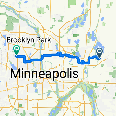
- Gateway Trail - Fleet Farm to DT Stillwater
- Distance
- 18.3 km
- Ascent
- 68 m
- Descent
- 150 m
- Location
- North Saint Paul, Minnesota, United States of America
- Twin Cities Lakes and Rivers 100K
- Distance
- 118.9 km
- Ascent
- 312 m
- Descent
- 298 m
- Location
- North Saint Paul, Minnesota, United States of America
Open it in the app