

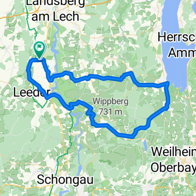
Unterdießen - Roßhaupten - Forggensee - Unterdießen
A cycling route starting in Unterdießen, Bavaria, Germany.
Overview
About this route
The route follows back roads and country lanes, using bike paths where possible.
- -:--
- Duration
- 124.9 km
- Distance
- 515 m
- Ascent
- 510 m
- Descent
- ---
- Avg. speed
- ---
- Max. altitude

Continue with Bikemap
Use, edit, or download this cycling route
You would like to ride Unterdießen - Roßhaupten - Forggensee - Unterdießen or customize it for your own trip? Here is what you can do with this Bikemap route:
Free features
- Save this route as favorite or in collections
- Copy & plan your own version of this route
- Split it into stages to create a multi-day tour
- Sync your route with Garmin or Wahoo
Premium features
Free trial for 3 days, or one-time payment. More about Bikemap Premium.
- Navigate this route on iOS & Android
- Export a GPX / KML file of this route
- Create your custom printout (try it for free)
- Download this route for offline navigation
Discover more Premium features.
Get Bikemap PremiumFrom our community
Other popular routes starting in Unterdießen
 kleine Tour
- Distance
- 39.2 km
- Ascent
- 124 m
- Descent
- 122 m
- Location
- Unterdießen, Bavaria, Germany
 Erpfting - Erpfting
- Distance
- 27.6 km
- Ascent
- 156 m
- Descent
- 155 m
- Location
- Unterdießen, Bavaria, Germany
 UD- - Bad Wörishofen - UD
- Distance
- 57.6 km
- Ascent
- 199 m
- Descent
- 198 m
- Location
- Unterdießen, Bavaria, Germany
 Bernbeuren - Dessau - Altenstadt - Hohenfurch - Kinsau
- Distance
- 77.1 km
- Ascent
- 336 m
- Descent
- 338 m
- Location
- Unterdießen, Bavaria, Germany
 Unterdießen-Stillern
- Distance
- 68.2 km
- Ascent
- 657 m
- Descent
- 656 m
- Location
- Unterdießen, Bavaria, Germany
 Erpfting
- Distance
- 56.3 km
- Ascent
- 247 m
- Descent
- 248 m
- Location
- Unterdießen, Bavaria, Germany
 Lechlauf_up
- Distance
- 63.5 km
- Ascent
- 533 m
- Descent
- 532 m
- Location
- Unterdießen, Bavaria, Germany
 Unterdießen - Altenstadt - Unterdießen "Knackig"
- Distance
- 56.7 km
- Ascent
- 333 m
- Descent
- 333 m
- Location
- Unterdießen, Bavaria, Germany
Open it in the app